


The Victorian ‘Drink Maps’ Wielded by Anti-Booze Crusaders
Author Kris Butler reveals how Temperance advocates mapped bars to discourage their spread.

“It’s a history of Temperance, it’s a little bit a history of beer, and it’s certainly a history of social reform,” says Kris Butler of her book Drink Maps in Victorian Britain, published in July. Informed by her background as a lawyer, Butler delves into the late 19th-century push for anti-liquor legislation manifested in the “drink map.” Although their name might suggest guides for planning bar crawls, drink maps were drafted with quite the opposite purpose in mind.
From the 1870s until the end of the 19th century, the anti-alcohol movement published maps indicating where liquor could be purchased in a given British city, in an attempt to convince lawmakers to stop granting liquor licenses. “Because you can look at it and go, ‘Oh, my God, there’s already way too many places to buy alcohol!’” Butler explains. Temperance organizations like the United Kingdom Alliance had drink maps produced for large cities like Liverpool and London as well as small towns, and paid for them to be published in pamphlets and newspapers with instructions for concerned citizens on how to get drink maps in front of the eyes of local magistrates and how to make their own.

Butler points out that at the height of the British Temperance movement, a small minority of the population was eligible to vote. For the many who could not, “this was their way to try to influence a lawmaker,” says Butler. Just one of many forms of grassroots Temperance activism, drink maps emerged from earlier “persuasive cartography”: maps designed to influence opinion and belief.

Drink maps ultimately fizzled out because “they didn’t seem to be working,” says Butler. She notes that although three drink maps were produced for the city of Norwich alone, it saw a decrease of only about 25 pubs in as many years. Butler credits the disappearance of drink maps to a combination of factors both within and outside the Temperance movement, including societal changes that led to an overall decline in habitual binge drinking.
Gastro Obscura spoke with Butler about the prevalence of drink maps in the 1880s and ’90s, why they fell out of favor, and how pubs could be likened to a plague.
What was your research process like? Was there earlier research on drink maps to consult?
The strange thing is, nobody has done this. [Drink maps] are spread all over the U.K. in tiny little archives, so researching them was really a labor of love, and driving. The British Newspaper Archive was an especially important resource, because some of the drink maps are published in newspapers, and I could also read about [liquor] licensing sessions.
I’ve now identified 30 [drink maps] that exist today, but there are hundreds that I’ve read about or found in the minutes of meetings, or looked in the local legislative process and they talk about consulting a drink map from that town, and they just don’t exist anymore. So I think there’s more out there. I’m hoping the book will inspire people, especially in the U.K., to look around and see if their local pub has one. I found two in pubs that libraries don’t have.
Are drink maps unique to the British Temperance movement, or were they also produced in other countries?
Drink maps were specific to targeting the U.K. magistrates, to try to get these lawmakers to stop granting licenses. So it had a really specific legislative, regulatory goal. In the U.S., there’s a very different licensing system, and of course, geographically, we’re so much bigger, so it would not have really made sense over here. I have one book with a handful of U.S. drink maps, which was published in the U.K., trying to demonstrate how some American cities could use them. And it never took off. There are definitely maps made during Prohibition in the U.S., trying to use an image to get people to not drink so much, but they’re more allegorical. It’ll be a pretend place with a line in the middle saying something like, “On this side, if you go down Drink Road, you’ll drown in Beer Lake.”

Where do drink maps fit in with earlier “persuasive maps” mapping negative activities?
The idea came from cholera maps. The most famous one was used in London to identify a specific water pump; the mapmaker went around and figured out where people were dying, and connected it to a certain water pump, and had the pump handle removed from the water source. That’s how they realized that cholera was spreading by water. That was in 1854, about 20 years before the first drink map was published.
I think that the first drink maps were [inspired by] the cholera maps. They even talk about the connection to sickness, to measles, to red bumps broken out on someone’s face. At the time, there was a split in the medical field about whether alcohol was restorative, and not a lot was really known about the effects of alcohol on the body.
At first, there were little pamphlets published about the evils of alcohol. It might connect alcohol to drug use and crime, and sometimes it would have a fold-out map, but the text was primary. Around 1878 is the first time that a drink map appeared on the face of the booklet, and on the back was text about how to use the map to try to get lawmakers to stop granting licenses.
Were there professional cartographers involved in making drink maps?
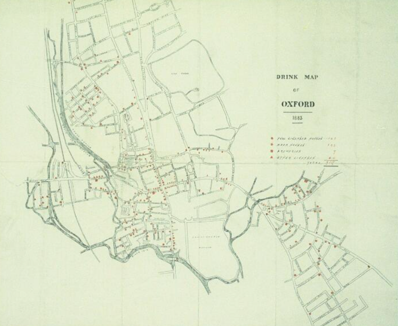
Some drink maps were truly handmade, like the drink map of Oxford, which is just a hand-drawn map printed locally, and there’s no known person who made it. But sometimes they would buy a base map. The YMCA, for example, was pretty prolific about making maps of different towns, and then leaving space for someone else to buy their base map and put their own interests on top of it. So no matter who bought it, they still had where all the YMCAs were indicated on the map.

How big of an impact on policy did drink maps actually have?
In one case [in 1882, in the borough of Over Darwen in Lancashire, England], after looking at a drink map, the magistrates decided to close half of the places to buy alcohol. Their rationale was, even if we close half of these, you still don’t have to walk more than two minutes to buy another beer, which I just think is the most beautiful rationale I’ve ever read. It was challenged, and it held up on appeal.
But magistrates were just local, the big fish in the small towns, and they didn’t want to cross the drink trade, which was very powerful. In some of the interviews I read at the time asking magistrates why they were still granting licenses, they said, “Well, we don’t want to get sued or challenged by the drink trade.” So they didn’t really stop granting licenses; it worked once, and then it really didn’t work after that.
What changes in the Temperance movement and British drinking culture at the end of the 19th century made drink maps obsolete?
The Temperance people found other strategies to be more effective than drink maps, like a tax increase. But other things did serve to lessen the amount of drinking that was going on. Historians point to social reform as the big picture, but just generally, people were happier and healthier. They had drinking fountains, parks, libraries, museums, things they just didn’t have at the end of the Industrial Revolution, when they were all packed into cities with nowhere to go, and nothing to do, but the church and the pub.
Drinking became more sociable. It became more common for men and women to go out and have a beverage together, and for the purpose not necessarily to be, “I got off work, I’m going to get shitfaced,” but instead to be, “It’s a social occasion, we’re nervous, let’s have a drink to loosen that up.”

What was the most surprising thing you learned in your research?
One thing that stood out is, I can now look at a map of a city and figure out where the magistrates lived, because there are no places to drink. They never approved licenses in their own neighborhoods. And if that wasn’t clear, if it showed the type of licenses, I could kind of figure out where the wealthy people lived, because on the edge of those neighborhoods would be the off-licenses. Meaning you can’t go sit there and drink, but you can go buy a bottle of whatever and take it home with you. So that’s where they would send their servants to go get the alcohol that they would consume at home. You can pick a map of any of these cities and figure out the economic geography of the city, based on where you can buy alcohol.
Interview has been condensed and edited for length and clarity.
Gastro Obscura covers the world’s most wondrous food and drink.
Sign up for our regular newsletter.


Follow us on Twitter to get the latest on the world's hidden wonders.
Like us on Facebook to get the latest on the world's hidden wonders.
Follow us on Twitter Like us on Facebook