About
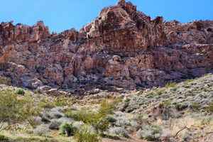
The geology in the vicinity of Lake Mead is complicated, reflecting a long history of overlapping deformation due to varying tectonic stresses, and this has led to some spectacular geologic features. Anniversary Narrows, in a slot canyon on Lovell Wash, is one such place. Here the wash has cut a narrow, twisted canyon through steeply dipping limestones of the Horse Spring Formation, which have been tilted into a ridge across the drainage.
Borax deposits occur in the sedimentary strata overlying the limestones, and they were mined intermittently from the 1920s to the mid-20th century, when competition from the new deposits at Boron, California, shut down most mining here. The major producer was the Anniversary Mine, for which the Narrows are named. Adits, ruins of foundations, and other mining remains will be seen while hiking in the wash up to the Narrows.
The hike through the Narrows is reasonably straightforward. Some scrambling will be required, and boots with good traction are a plus because the rocks are slick due to water polish. At one point a vertical drop of about five feet needs to be negotiated. Dogs on lead are permitted on the trail, but will need to be lifted over some of the obstacles.
Related Tags
Know Before You Go
Anniversary Narrows is near the North Shore Road (Nevada State Route 167) north of Lake Mead. The easiest way in is to turn north off SR-167 onto the Callville Wash Road (at about 36.19639 N, 114.68724 W). Go about 1/4 mile and turn left on Anniversary Mine Road (at about 36.19853 N, 114.68453 W), and follow as it winds around about 1.75 miles. High clearance and possibly 4wd will be required; if the road becomes impassible park and follow it on foot. There are a number of branches and loops, but your ultimate goal is Lovell Wash (the prominent drainage on the left); just keep bearing that way. The old road intersects the wash at a washout about 36.21354 N, 114.70668 W. Then follow the wash upstream about 0.6 mile to the beginning of the Narrows.
Alternatively, you can go into the old Anniversary Mine site, on the west side of Lovell Wash. Turn north on the West End Wash Road (at about 36.19129 N, 114.73470 W), which winds around and drops into West End Wash in a few hundred yards. Follow the wash upstream about 0.66 mile to where the Anniversary Mine Road takes off on the right (at about 36.20049 N, 114.73832 W). Turn right here. This road winds around for about 2 miles to end at the old mine site above Lovell Wash. Park here. Drop down into the wash (along the old road is easiest) and follow it upstream as above. (You could follow the road down with your vehicle, but there's no place to park at the end.) This is a very rough road on which high clearance and 4wd will be required. It used to connect to the road on the east side of Lovell Wash, but the crossing at the wash is now thoroughly washed out.
Until recently there were access issues because of crossing the old mining claims, which remained private land, but these have evidently been resolved as of March 2024.
Community Contributors
Added By
Published
July 1, 2024