About
Water is needed for human survival, and for transportation, so it's no surprise that many old cities are built near rivers. But rivers bring with them the danger of flooding. Heidelberg's Old Bridge commemorates some of the worst instances of the Neckar flooding over the course of the city's history.
The Karl-Theodor Bridge, commonly known as Alte Brücke (Old Bridge), dates back nearly 250 years. But a bridge has crossed the Neckar near this point since the 13th century. Floods and ice storms have destroyed many of those bridges, requiring the construction of a new one.
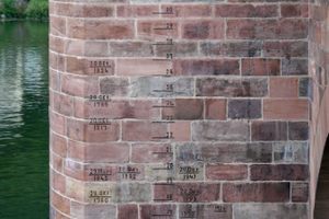
A support on the southwestern side of the bridge bears markings of those previous floods. The water level is measured with an old unit called the Baden foot, which is close to the current foot used in the Imperial measurement system. The highest marking is 8.3 meters above the current water level, and dates back to 1784, when a catastrophic ice flood destroyed a previous iteration of the bridge.
Related Tags
Know Before You Go
The markings are freely accessible.
Published
August 15, 2024