About
88 miles northeast of Las Vegas, New Mexico lies the Kiowa National Grassland, a seemingly flat plain of, well, not much of anything. Ranches. Tumbleweeds. Telephone poles. That’s about all you’ll see from Route 39, until you turn off on Mills Canyon road and head west for a few miles. And then, all of sudden, the plains drop into a canyon carved over millennia by the Canadian River.
There’s a campground right before the road drops into the canyon, and then another campground down in the canyon itself. It’s a stunning view as you head down the canyon to its floor, which is what entrepreneur Melvin Mills must have thought when he built an orchard and farm here in the late 1800s, bringing the first modern attention to the lovely area.
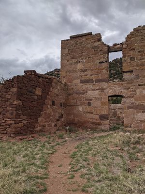
But unfortunately for Mills, a massive flood wiped out his orchard a scant decade later, in 1904. Mills chose not to rebuild, so now, 110 years later, a group of terrific ruins remain in the middle of this stunning canyon that the Canadian River snakes through.
The area is also not only sparsely populated but also not well known among campers and hikers, so the only encounter you are likely to have at the site will be with some prancing antelope and crumbling pieces of history.
The national grasslands were created by Title III of the Bankhead–Jones Farm Tenant Act of 1937, when the Great Plains was devastated by the catastrophic Dust Bowl of the 1930s and the Great Depression had left farm families destitute. The national grasslands are areas of protected and managed federal lands. They are essentially identical to national forests, except that grasslands are areas primarily consisting of prairie. The idea was to take out of production abused marginal farmland and allow it to regenerate as a means of combating the Dust Bowl.
Related Tags
Know Before You Go
Turnoff to Mills Canyon Road is 16 miles south of Abbot, NM on Rt. 39; it's about 10 miles north of Roy, NM on Rt. 39.
Published
September 29, 2014


