About
One of the most climbed mountains in the world, Mount Monadnock sees many hikers on its peak, but thats about all that's left up there after early settlers burnt the peak barren a couple of times.
Mountaineers and New Englanders flock to Mount Monadnock, rising 3,185 feet above sea level-- making it the highest in Cheshire County, New Hampshire-- during all four seasons for hiking, climbing, camping, and cross-country skiing. The name comes from an Abenaki word meaning "that which stands alone" and is used in more general terms to describe any isolated American mountain, miles away from any neighbors, that formed from harder rock on its top as opposed to its surrounding soil being eroded away. Other mountains in New England share this name, one in Vermont and several-- Pack Monadnock, North Pack Monadnock, Little Monadnock-- in southern New Hampshire.
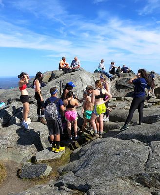
Unlike other New England mountains of Monadnock's altitude and higher, Monadnock has a stark tree line which is the result of a pair of massive fires that left the peak completely bald. The first was set in 1801 to clear the slopes for pastureland, annihilating the native virgin red spruce forest. A few years later, a second fire was set by local ranchers who believed wolves were holed up on the peak. This raged out of control and consumed all the remaining wood and topsoil on the peak, leaving the granite bedrock completely exposed. Now, only scattered krummholz can be seen above tree line.
Despite, or maybe even because of, the peak's history, an average of 125,000 people climb this mountain every year making it one of the most frequented peaks in the world. The views of the southern New Hampshire forests dominate in every direction, and on a clear day, the rough, bare, schist peak that was forged in fire can be seen from as far as Boston.
Many trail options lead to the summit. The popular Halfway House route follows an old road to the site of a hotel, located approximately halfway up the mountain.
Related Tags
Know Before You Go
For the White Dot Trail, from Jaffrey, NH, go west on Route 124, then turn at the sign. Pay the use fee, park, and follow signage to the trailhead. Hike and climb 2 miles to the summit.
Community Contributors
Added By
Published
November 18, 2014

