Trips Places Foods Stories Newsletters

Take your next trip with Atlas Obscura!

Our small-group adventures are inspired by our Atlas of the world's most fascinating places, the stories behind them, and the people who bring them to life.

Visit Adventures
Trips Highlight
Slovenia mushroom foraging
Slovenia • 6 days, 5 nights
Forest to Table in Alpine Slovenia
from
Central Asia yurt night stars
Uzbekistan • 15 days, 14 nights
Central Asia Road Trip: Backroads & Bazaars
from
View all trips
Top Destinations
Latest Places
Most Popular Places Random Place Lists Itineraries
Add a Place
Download the App
Top Destinations
View All Destinations »

Countries

  • Australia
  • Canada
  • China
  • France
  • Germany
  • India
  • Italy
  • Japan

Cities

  • Amsterdam
  • Barcelona
  • Beijing
  • Berlin
  • Boston
  • Budapest
  • Chicago
  • London
  • Los Angeles
  • Mexico City
  • Montreal
  • Moscow
  • New Orleans
  • New York City
  • Paris
  • Philadelphia
  • Rome
  • San Francisco
  • Seattle
  • Stockholm
  • Tokyo
  • Toronto
  • Vienna
  • Washington, D.C.
Latest Places
View All Places »
“Yo Soy el Buen Pastor Ego Sum Pastor Bonus” by Bernardo Ramonfaur.
Museo Arquidiocesano de Arte Sacro (Archdiocese Sacred Art Museum)
Burke Building.
Burke Building
‘La Grande Assiette Brisée’ (‘The Large Broken Plate’)
Ellijay Mushrooms Farm
Latest Places to Eat & Drink
View All Places to Eat »
View of the full general store from the second floor.
MoonPie General Store
A slice of cake is the perfect coda to a meal at Piatto Romano.
Piatto Romano
Crunchy and supremely satisfying, suppli might be the ultimate street food snack.
Supplizio
The pedigreed pistachios here are from Bronte.
Gelateria dei Gracchi
This tiny hole-in-the-wall serves one of the world’s most magnificent sandwiches.
Er Buchetto
Recent Stories
All Stories Video Podcast
Most Recent Stories
View All Stories »
Our journey begins in Texas—more specifically in Big Bend National Park.
The Atlas Obscura (Audio) Guide to the National Parks
about 23 hours ago
While initially unsanctioned, Toronto’s graffiti community converted this largely ignored alleyway into an epicenter of world-class street art.
10 Unexpected Places Where Creativity Shines in Toronto
about 23 hours ago
Prehistoric creatures roam the grounds of the Dinosaur House.
Roadside Dinosaurs: An American Love Story
about 24 hours ago
There’s No Right Way to Say ‘Taco’
1 day ago

No search results found for
“”

Make sure words are spelled correctly.

Try searching for a travel destination.

Places near me Random place

Popular Destinations

  • Paris
  • London
  • New York
  • Berlin
  • Rome
  • Los Angeles
Trips Places Foods Stories Newsletters
Sign In Join
Places near me Random place
All the United Kingdom England London River Tyburn Conduit

River Tyburn Conduit

A plaque marks the underground site of one of London's "lost rivers."

London, England

Added By
AmunyAnkhesenra
Email
Been Here
Want to go
Added to list
River Tyburn Conduit.   AmunyAnkhesenra / Atlas Obscura User
Confluence of the “lost river’ Tyburn with the Thames.   Jim Linwood/CC BY 2.0
Marylebone Lane’s unusual curves follow the river’s old path.   Map Data © 2017 Google
  SEANETTA / Atlas Obscura User
  SEANETTA / Atlas Obscura User
  SEANETTA / Atlas Obscura User
Been Here
Want to go
Added to list

About

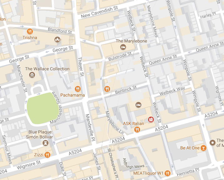
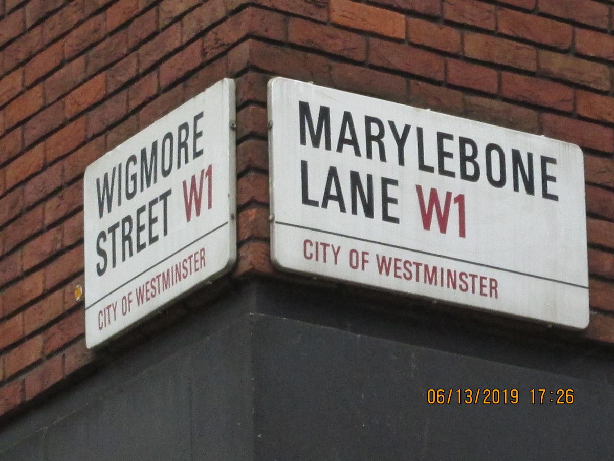
In London, the layout of the streets to the north of Oxford Street is one of fairly logical grid patterns. But there’s one notable exception: Marylebone Lane, which winds its way to its connecting streets in an unusually curvy way. The lane’s nonconforming path is due to the fact that it once followed the River Tyburn, one of the many “lost rivers" of London.

In the past, the Tyburn portioned off one of London’s borders. The “ty” portion of its name even derives from a word for “boundary.” The village of Tyburn, which was recorded in the Domesday Book, once sprouted up around the river. Oxford Street and Park Street, which are in the vicinity of the ancient waterway’s former path, were previously named after the Tyburn as well. The river was supposedly a good place for local fishermen.

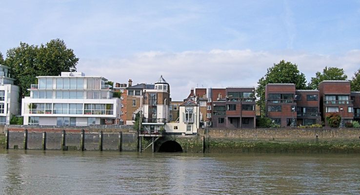
In addition to supplying plentiful fish, the Tyburn was also a key source of water for the city. However, like many of the other tributaries of the Thames, as London expanded, it was eventually culverted for its entire length. One conduit even flows under Buckingham palace.

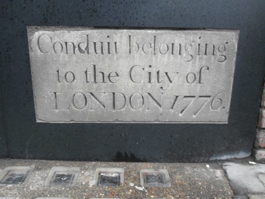
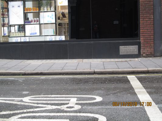
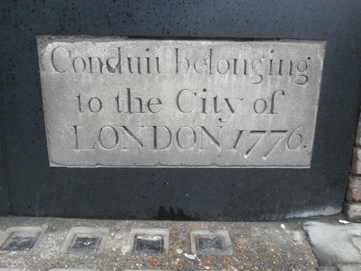
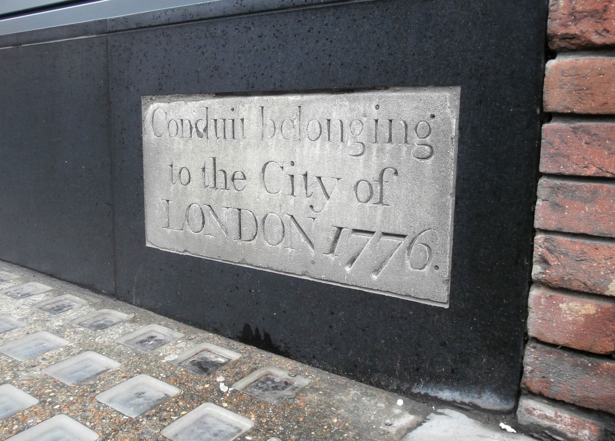
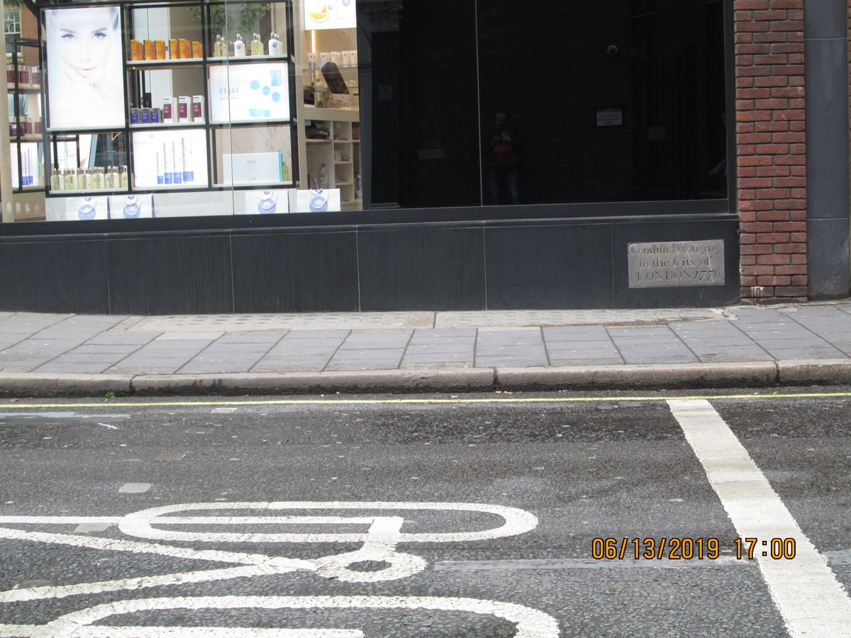
Even after it was sent underground, the river was still used as a water supply. One of the few remaining traces of the river can be seen thanks to this, in the form of a small plaque built into a wall on Marylebone Lane. This dates the construction of the conduit by the City of London to 1776. The river still flows through it, under the feet of many unaware pedestrians.

The Tyburn Angling Society has proposed plans to restore the river to its original grandeur so it can once again be a prime fishing spot. However, doing this is a highly unfeasible act, as it would require demolishing important property like Buckingham Palace.

Related Tags

Rivers Urban Planning Water Roads Cities History Geographic Oddities

Know Before You Go

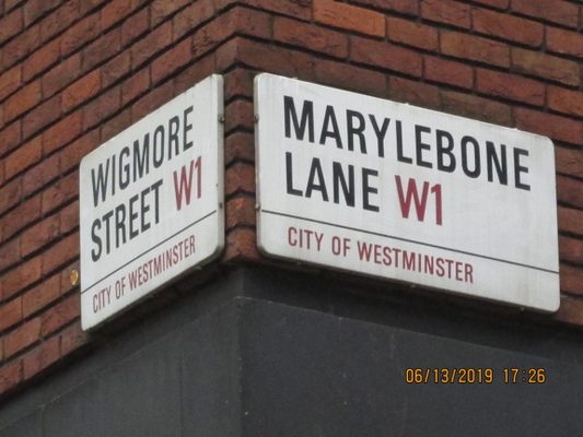
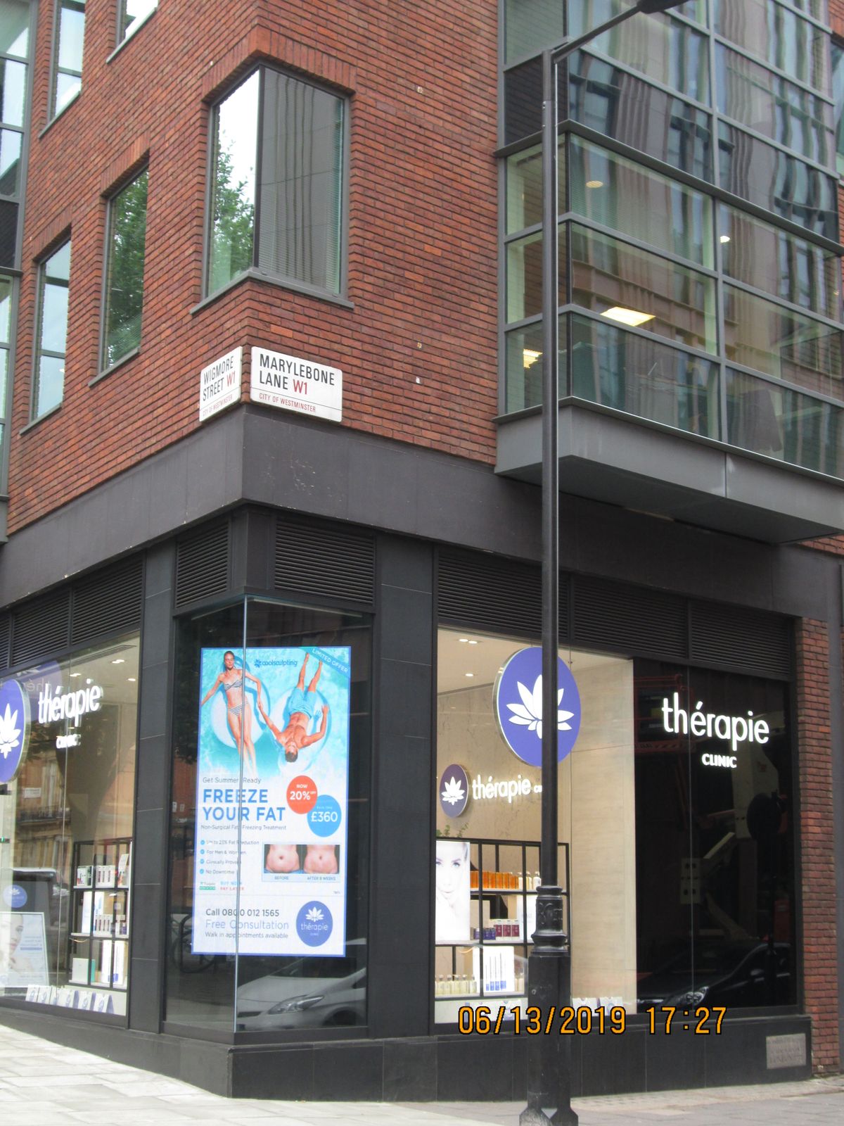
The plaque can be found at the corner of Marylebone Lane and Wigmore Street.

It's at floor level on the side of the therapy clinic building. 

Community Contributors

Added By

AmunyAnkhesenra

Edited By

Akki14, jooniur, SEANETTA, Kerry Wolfe

  • Akki14
  • jooniur
  • SEANETTA
  • Kerry Wolfe

Published

September 5, 2017

Edit this listing

Make an Edit
Add Photos
Sources
  • http://www.bbc.com/news/uk-england-london-29551351
  • https://www.theguardian.com/environment/2009/jan/08/river-restoration-london
  • http://www.telegraph.co.uk/travel/destinations/europe/united-kingdom/england/london/articles/london-lost-underground-rivers-hidden-history/
  • https://en.wikipedia.org/wiki/River_Tyburn
  • http://www.londonslostrivers.com/river-tyburn.html
  • http://www.atlasobscura.com/articles/infiltrating-london-subterranean-exploration-in-the-british-capital
River Tyburn Conduit
50 Marylebone Ln
London, England, W1U 2AD
United Kingdom
51.516156, -0.149522
Get Directions

Nearby Places

British Dental Museum

London, England

miles away

The Wallace Collection Armory

London, England

miles away

William Blake's Home

London, England

miles away

Explore the Destination Guide

Photo of London

London

England

Places 536
Stories 108

Nearby Places

British Dental Museum

London, England

miles away

The Wallace Collection Armory

London, England

miles away

William Blake's Home

London, England

miles away

Explore the Destination Guide

Photo of London

London

England

Places 536
Stories 108

Related Places

  • The underlying River Farset causes the clock tower to tilt.

    Belfast, Northern Ireland

    River Farset

    Belfast's namesake river still winds below the city center, hidden from sight.

  • The beach facing Brisbane City and River.

    Brisbane, Australia

    Streets Beach

    Brisbane's manmade urban beach has enough water to fill five Olympic-sized swimming pools.

  • Cromwell’s Corners was once called Murdering Lane.

    Dublin, Ireland

    Murdering Lane and Cutthroat Lane

    Though they've since been renamed, these two streets hint at Dublin's darker days.

  • Spring Lane, which was named after the Great Spring.

    Boston, Massachusetts

    The Great Spring

    A tiny plaque marks the location of the water source that facilitated the birth of modern-day Boston.

  • Mumbai, India

    Flora Fountain

    An iconic fountain dedicated to the Roman goddess Flora stands in the heart of Mumbai.

  • Brussels, Belgium

    Largest Paving Stone in Belgium

    This huge limestone slab is considered the largest paving stone in Belgium and a relic of the earliest modern paving in Brussels.

  • Sign for L13

    Mannheim, Germany

    Mannheim Quadratestadt

    In this German city center, the streets have no names.

  • The cascade near the Voskhod (Vostok) One neighborhood, features concrete diving piers. Signs remind parkgoers not to dive or swim in the stream

    Minsk, Belarus

    Slepianskaya Waterway System

    A system of constructed rapids and concrete waterfalls in a linear park on the Slepnya River.

Aerial image of Vietnam, displaying the picturesque rice terraces, characterized by their layered, verdant fields.
Atlas Obscura Membership

Become an Atlas Obscura Member


Join our community of curious explorers.

Become a Member

Get Our Email Newsletter

Follow Us

Facebook YouTube TikTok Instagram Pinterest RSS Feed

Get the app

Download the App
Download on the Apple App Store Get it on Google Play
  • All Places
  • Latest Places
  • Most Popular
  • Places to Eat
  • Random
  • Nearby
  • Add a Place
  • Stories
  • Food & Drink
  • Itineraries
  • Lists
  • Video
  • Podcast
  • Newsletters
  • All Trips
  • Family Trip
  • Food & Drink
  • History & Culture
  • Wildlife & Nature
  • FAQ
  • Membership
  • Feedback & Ideas
  • Community Guidelines
  • Product Blog
  • Unique Gifts
  • Work With Us
  • About
  • FAQ
  • Advertise With Us
  • Advertising Guidelines
  • Privacy Policy
  • Cookie Policy
  • Terms of Use
Atlas Obscura

© 2025 Atlas Obscura. All Rights Reserved.