Trips Places Foods Stories Newsletters

Take your next trip with Atlas Obscura!

Our small-group adventures are inspired by our Atlas of the world's most fascinating places, the stories behind them, and the people who bring them to life.

Visit Adventures
Trips Highlight
Street art in Cartagena.
Colombia • 10 days, 9 nights
Colombia Discovery: Coffee, Art & Music
from
Caucasus - Geghard Monastery, Armenia
Armenia • 15 days, 14 nights
Caucasus Road Trip: Azerbaijan, Georgia & Armenia
from
View all trips
Top Destinations
Latest Places
Most Popular Places Random Place Lists Itineraries
Add a Place
Download the App
Top Destinations
View All Destinations »

Countries

  • Australia
  • Canada
  • China
  • France
  • Germany
  • India
  • Italy
  • Japan

Cities

  • Amsterdam
  • Barcelona
  • Beijing
  • Berlin
  • Boston
  • Budapest
  • Chicago
  • London
  • Los Angeles
  • Mexico City
  • Montreal
  • Moscow
  • New Orleans
  • New York City
  • Paris
  • Philadelphia
  • Rome
  • San Francisco
  • Seattle
  • Stockholm
  • Tokyo
  • Toronto
  • Vienna
  • Washington, D.C.
Latest Places
View All Places »
The wall commemorating 11,908 Jewish victims of the Shoah from Frankfurt.
Börneplatz Memorial
Entrance to the munitions area of the lower part of the bunker
Simserhof
Carlos Calderón Yruegas calls the villa his personal playground.
Villa Tabaiba
Apples and pears, Spitalfields Market.
Brick Lane Roundels
Latest Places to Eat & Drink
View All Places to Eat »
The sign declares this the number-one gumbo shop in town.
Gumbo Hut Shioya
The pavlova comes crowned with jewel-like fruit.
Central Park Boathouse
The Village Tavern of Long Grove - exterior.
The Village Tavern
Hunter House Hamburgers
L’Escamoteur
Recent Stories
All Stories Video Podcast
Most Recent Stories
View All Stories »
USDA and Washington State agriculture officials tagged this Asian giant hornet. Sept. 10, 2021.
What Ever Happened to the Murder Hornets?
about 1 hour ago
The exterior of the Hall of Records.
Atlas Obscura Mailbag: Urban Exploration, Illegal Carvings, and Repeat Vacations
2 days ago
Biosphere 2 campus (2016)
Biosphere 2: How Volunteers Survived for 2 Years in an Airtight Habitat
3 days ago
Places like Forest Grove linger on the edge of wilderness and civilization.
Listening for Echoes of the Forest Grove Sound
3 days ago

No search results found for
“”

Make sure words are spelled correctly.

Try searching for a travel destination.

Places near me Random place

Popular Destinations

  • Paris
  • London
  • New York
  • Berlin
  • Rome
  • Los Angeles
Trips Places Foods Stories Newsletters
Sign In Join
Places near me Random place
All the United States Maryland Delmar Transpeninsular Midpoint Marker

Transpeninsular Midpoint Marker

The stone marker that Mason and Dixon placed at the eastern end of the famous north-south border they surveyed.

Delmar, Maryland

Added By
Brett Iredell
Email
Been Here
Want to go
Added to list
Mason-Dixon survey stone.   WhiskeyBristles / Atlas Obscura User
Various survey stones, the Mason-Dixon stone is on the left.   WhiskeyBristles / Atlas Obscura User
Informational plaque   blimpcaptain / Atlas Obscura User
Mason Dixon marker - Delmar   beachedpaws / Atlas Obscura User
The shelter around the survey markers.   WhiskeyBristles / Atlas Obscura User
Been Here
Want to go
Added to list

About

Granting charters to form colonies in Colonial America was an unorganized, hodgepodge affair, and sometimes the same property was accidentally bequeathed to multiple parties. That's exactly what happened on the Maryland-Pennsylvania border, where Lord Baltimore and William Penn both received claims to colonies that overlapped a considerable amount.

Initially, however, the vagary of the borders was largely ignored. It wasn't until they began to significantly affect the collecting of taxes from settlers that the aristocracy of the colonies took an interest. Maryland's charter predated Pennsylvania's by several decades but it was poorly surveyed, having been based on earlier, more inaccurate maps. Also, according to Maryland's charter, the land that ended up becoming the city of Philadelphia fell within Maryland borders, which was obviously unacceptable to the Pennsylvania colony. An additional wrinkle—Delaware was being administered by Pennsylvania but Maryland claimed that land was granted to them by their charter.

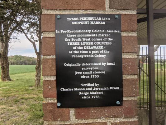
The English courts largely settled the issue in Pennsylvania's favor. It was decreed that the border between Maryland and Pennsylvania would be resurveyed to an east-west line at a point 15 miles south of Philadelphia, and Delaware was formally ruled to not be a part of Maryland's charter. After more decades of legal wrangling, and several improved but still flawed surveys of the border, the colonies mutually decided to hire professionals from England to sail over and do a proper job. To this end, astronomer Charles Mason and surveyor Jeremiah Dixon were hired on July 20th, 1763 and paid £3,512, or approximately $840,000 in 2017, adjusted for inflation.

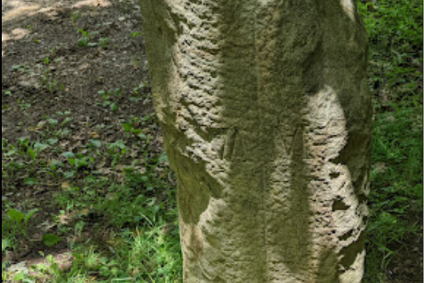
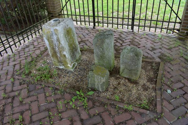
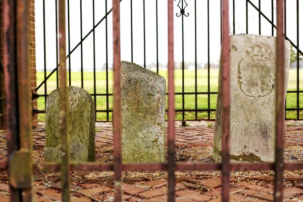
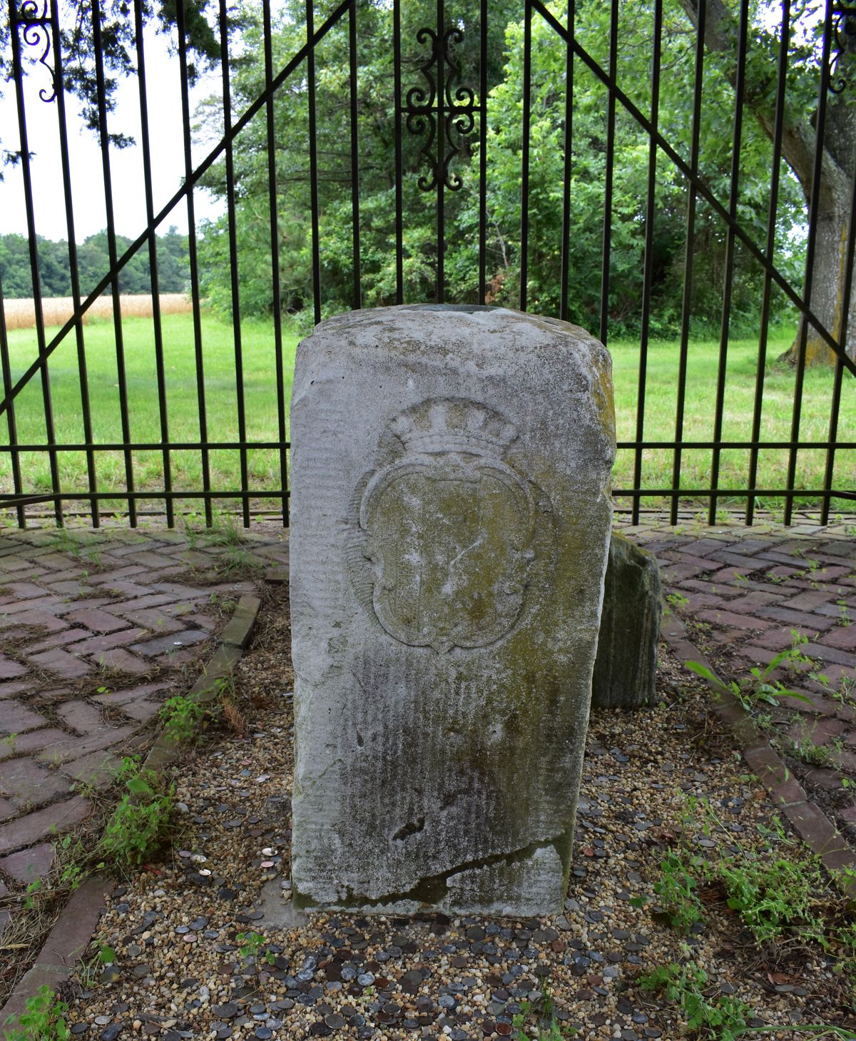
Over the following four years, Mason and Dixon walked every inch of the border, leaving a stone marker at each mile along the way. The southernmost point of the Maryland-Delaware border, where it nearly makes a right angle and forms the southwest corner of Delaware, was known as the Transpeninsular Midpoint. It marks the eastern end of what became known as the Mason-Dixon line, the informal boundary delineating the North from the South in the United States.

In 1769, after nearly nine decades of dispute, the borders between the colonies was approved by King George III and finally settled. Only seven years later, however, the Calvert and Penn families lost their colonies due to the American Revolution when the American colonies declared their independence from England.

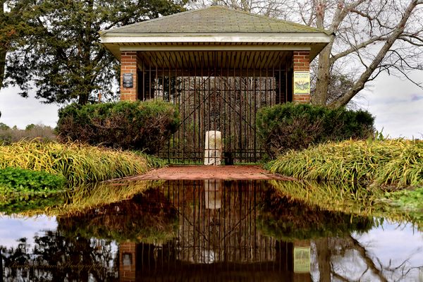
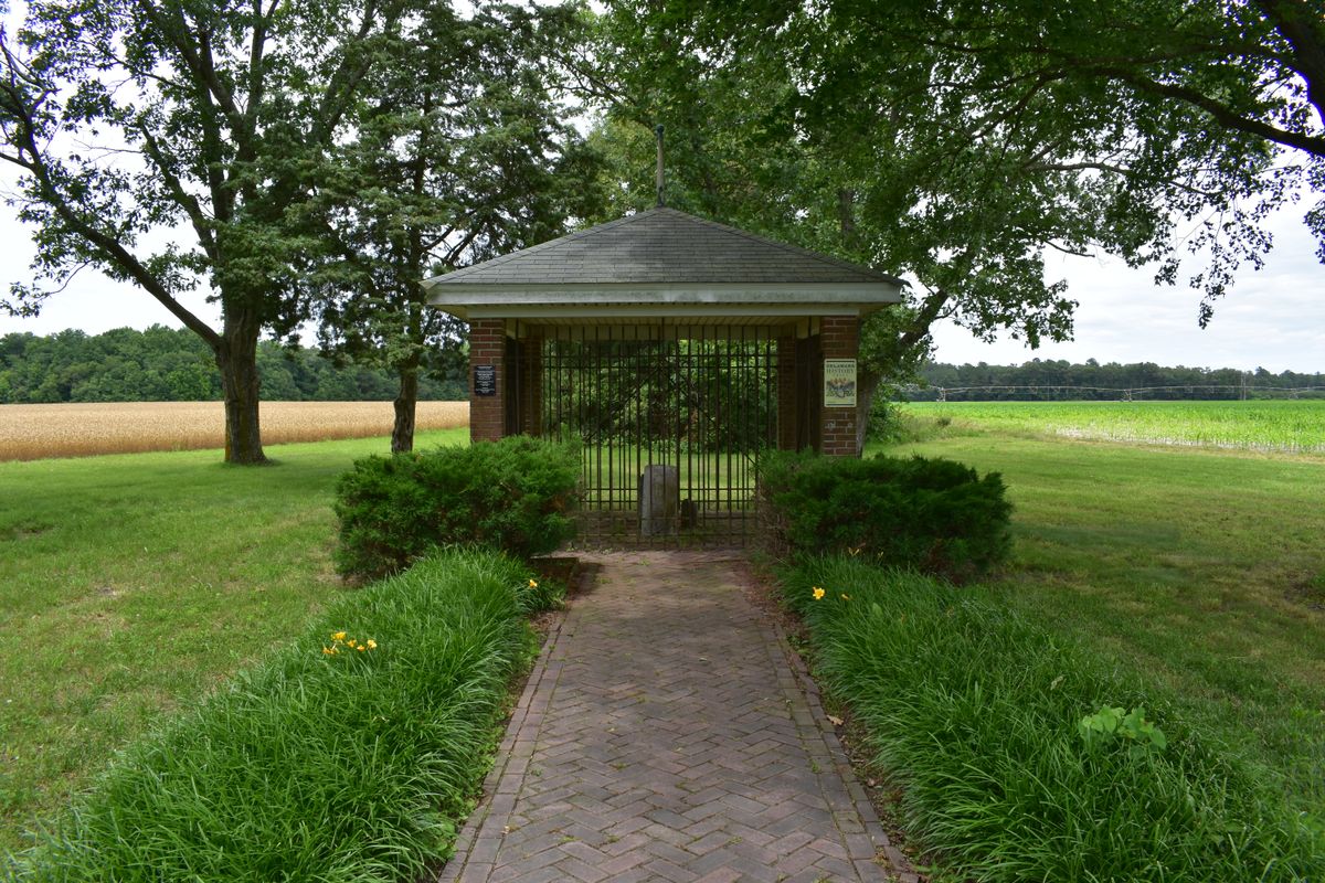
Today, you can still see the stone marker that Mason and Dixon placed to mark one end of the famous borders that they surveyed, under a small shelter on the side of the highway, adjacent to other stones marking earlier attempts at the border.

Related Tags

Surveyors Borders Border Crossings Geographic Markers Geographic Oddities Maps

Know Before You Go

The survey stones are on the side of the highway where route 54 crosses the Maryland-Delaware border. There is a small pull-off where you can park.

Community Contributors

Added By

WhiskeyBristles

Edited By

beachedpaws, blimpcaptain

  • beachedpaws
  • blimpcaptain

Published

June 22, 2017

Edit this listing

Make an Edit
Add Photos
Sources
  • https://en.wikipedia.org/wiki/Mason%E2%80%93Dixon_line
  • https://en.wikipedia.org/wiki/Penn%E2%80%93Calvert_boundary_dispute
  • https://www.hmdb.org/marker.asp?marker=74130
Transpeninsular Midpoint Marker
180906-263648 MD-54
Delmar, Maryland
United States
38.460108, -75.693526
Get Directions

Nearby Places

Highball Signal

Delmar, Delaware

miles away

Ward Museum of Wildfowl Art

Salisbury, Maryland

miles away

Site of the Tilly Escape

Seaford, Delaware

miles away

Explore the Destination Guide

Photo of Maryland

Maryland

United States

Places 239
Stories 15

Nearby Places

Highball Signal

Delmar, Delaware

miles away

Ward Museum of Wildfowl Art

Salisbury, Maryland

miles away

Site of the Tilly Escape

Seaford, Delaware

miles away

Explore the Destination Guide

Photo of Maryland

Maryland

United States

Places 239
Stories 15

Related Places

  • Semināra iela/Sepa tänav border.

    Valga, Estonia

    Valga/Valka Border

    For the last century, this international border within a small town has appeared and disappeared various times.

  • Tri-States Monument and Delaware River

    Port Jervis, New York

    Tri-States Monument

    A pair of 19th-century granite markers symbolically record where the state boundaries of New York, New Jersey, and Pennsylvania intersect.

  • Markleysburg, Pennsylvania

    Old Tri-State Monument

    This original Mason-Dixon line cairn placed in the 1760s was put in the wrong location because of the gravitational pull of the Allegheny Mountains.

  • Ras Angela

    Ras Angela, Tunisia

    Ras Angela

    The northernmost point of continental Africa—or is it?

  • Berlin, Germany

    Steinstücken Exclave

    A helicopter memorial commemorating what was once the only way to access this West Berlin exclave.

  • Concordia Monument

    Belvedere, Sint Maarten

    Concordia Monument

    Where Saint-Martin ends and Sint Maarten begins (or vice versa).

  • Cameron Corner, Australia

    Cameron Corner

    The point where New South Wales meets Queensland and South Australia.

  • The Center of Google Earth mural in Chanute, Kansas.

    Chanute, Kansas

    Center of Google Earth Mural

    A Google software engineer's Easter egg led to what may be the world's most unusual saved screenshot.

Aerial image of Vietnam, displaying the picturesque rice terraces, characterized by their layered, verdant fields.
Atlas Obscura Membership

Become an Atlas Obscura Member


Join our community of curious explorers.

Become a Member

Get Our Email Newsletter

Follow Us

Facebook YouTube TikTok Instagram Pinterest RSS Feed

Get the app

Download the App
Download on the Apple App Store Get it on Google Play
  • All Places
  • Latest Places
  • Most Popular
  • Places to Eat
  • Random
  • Nearby
  • Add a Place
  • Stories
  • Food & Drink
  • Itineraries
  • Lists
  • Video
  • Podcast
  • Newsletters
  • All Trips
  • Family Trip
  • Food & Drink
  • History & Culture
  • Wildlife & Nature
  • FAQ
  • Membership
  • Feedback & Ideas
  • Community Guidelines
  • Product Blog
  • Unique Gifts
  • Work With Us
  • About
  • FAQ
  • Advertise With Us
  • Advertising Guidelines
  • Privacy Policy
  • Cookie Policy
  • Terms of Use
Atlas Obscura

© 2025 Atlas Obscura. All Rights Reserved.