When Land Surveys Were a Modern Marvel
In 1784, Thomas Jefferson and Alexander Hamilton squared off over the best way to divvy up newly American territory.

On September 30, 1785, Thomas Hutchins, the first and only Geographer of the United States, set out to divide the country’s Western lands into neat, square parcels. He was supposed have a team of 13 men, one representing each new state, but only eight had shown up. At least three had an ulterior motive—they were allied with private investment companies eager to scout out land that would soon put up for sale.
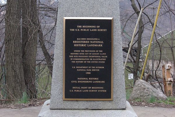
The project Hutchins and his team were embarking on was innovative and massively ambitious, but it began in a small way, at a wooden post staked on the north bank of the Ohio River, at the western border of Pennsylvania. With a couple of simple measurement tools and a compass, the men started their work, measuring and marking out a line due west into Ohio. It took them more than a week to work over four miles, and that was it for the year. Hutchins was not willing to travel farther west and risk running into the violent conflict with the Lenape, which had sparked after a Pennsylvania militia massacred 96 people.
That four-mile line was the beginning of the Public Land Survey, which divided all public land in the United States into parcels six miles square. The project that began that day on the Pennsylvania border was so tremendous that it is still going on and now includes close to 1.5 billion acres.
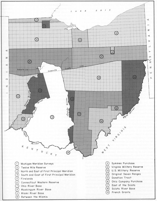
Though it’s taken for granted today, the systematic division of land in the United States still defines the country’s geographical fate. In its early stages, the survey pit Thomas Jefferson and Alexander Hamilton against one another, with their competing visions of who should own and profit from America’s land, and it enabled America’s great land grab from the native people of the continent’s Western reaches. More than 230 years later, the same system still governs distributions of mineral rights on public lands and underlies digital mapping systems. If you know what to look for, you can still find its legacy in the physical markers that dot the land today, in the neat divisions of the Western states, and particularly in Ohio, where a not-yet-perfected survey system created messy, irregular divisions that still hash the state.

The Public Land Survey System was created because, in the 1780s, the new United States of America needed money. The Revolutionary War had left the federal government with debts, and its leaders planned to raise funds by selling off land where American colonists had yet to settle.
They knew they would have buyers, as C. Albert White writes in A History of the Rectangular Survey System, a delightful and comprehensive account of land divisions in the U.S. “The land-speculating companies began early to petition the Congress for land grants,” writes White, who worked for years as a cadastral surveyor for the Bureau of Land Management. “Wealthy and influential men held stock in these companies and also held large amounts of continental currency and treasury notes.” They’d buy up the land and later resell it to settlers—at a gain, of course.
There were divisions, though, among the country’s politicians about how to sell the land. Alexander Hamilton, who was working around this time to create the Bank of New York, and John Jay, who came from a wealthy New York family, favored selling to large land companies. But their political opponents, Thomas Jefferson, most notably, wanted to divide the land into small parcels and sell them off to individuals—the farmers that Jefferson thought so crucial to democracy.
The two factions also had different ideas about how to divide the land. Jefferson and his allies wanted to use an innovative system of land division, which would use meridians and other abstract geographical reference points to measure out uniform parcels of land. Hamilton and his allies thought that would take too long. As long as settlers had been grabbing up land in America, they’d operated according to a principle of free settlement—essentially, first-come, first-serve. Hamilton wanted to divide up the land using the more traditional “metes and bounds” system, in which landmarks and other features of a piece of land are used to describe its borders.
Jefferson, though, headed the committee that created the plan to deal with the land. Jefferson had spent time in the surveying trenches, measuring out Virginia, and may have written the first draft of the committee’s plan himself. It called for the territories in the West to be divided into regular squares, along lines that ran north/south and east/west and, originally, for the land to be sold by township, each measuring seven square miles, or 4,480 acres. By the time the law was passed, though, the Jefferson faction had managed to reduce the unit of sale to just 640 acres.
All that remained was for those lots to be measured out. Today, surveyors have tools that help them do the job with precision. But for the men engaged in this line of work in the 1780s, drawing straight lines would require trial and error—a lot of error, as it turned out.

Hutchins and his team returned to Ohio the next year, and they kept working west. After six miles was measured out, one of the surveyors started a new line, this one running south. As the “Geographer’s Line” ran west, one of the other surveyors would start running a line south every six miles. At each corner, the surveyors would select a physical signal—either a wooden post or a tree—to mark the boundary. By the end of the season, they had marked out four townships; by June 1787, they had finally finished measuring out the first seven townships under the new system.
There were some issues. “In retrospect, the system of numbering the townships was very confusing and cumbersome,” White writes in his book. More importantly, though, the lines the surveyors drew weren’t quite straight. When they measured out a six-mile side of a township, they’d mark a corner, at a right angle to the other side. But, as White writes, “The surveyors were apparently all individuals with individual concepts of how to comply with the ‘six miles square’ and ‘right angle’ requirements.” Often, the person running the east-west line and person running the north-south line would each mark a corner, whether or not that measurement agreed with any previous one. In some places, a single corner had multiple markers, “anywhere from one to four corners supposedly standing for what in theory should have been a common corner of all four townships,” writes White.
Those problems, though, were small compared to the errors in the next large surveys of land. Congress sold two large tracts of Ohio land to land companies. The first, the Ohio Company, did a decent job surveying its land, according to the principles set out by law, although the company used its own unique and confusing numbering system. But the second private company botched the job. The private surveyors running the lines did such bad work that a person buying a lot of 640 acres might end up with 100 acres less than he paid for, according to White. The results of these experiments can still be seen in Ohio today, where the land is divided up without the regularity of plots farther west.
At that point, the government turned back to Alexander Hamilton, who had been appointed Treasury Secretary. Hamilton’s new idea was to create a new government agency, the General Land Office, to oversee land sales and surveys. Within the next few years, as boundary disputes multiplied, Congress took up part of his recommendation and created land offices to keep track of who owned what. It took another decade of disputes before the government finally got a federal land office to oversee the whole process.

The Public Land Survey System was haunted by problems with private surveyors for years: in 1966, the BLM was still working to correct fraudulent surveys done in California in the 19th century. But over decades of work, the Surveyor General and his legions of surveyors improved the accuracy and technique of dividing up land. In the 1890s, after decades of requests, the survey system got funding for more permanent markers—they used iron posts to mark each township corner and small stone “monuments” in corners marking smaller tracts.
By the time White published his book in the 1980s, there were still some unresolved mysteries of the survey and work to be done to correct the earlier, wilder measurements. Even today, the survey’s not entirely finished: there are large swaths of Alaska that have never been marked out. (It really is that giant.) But those early efforts are still evident in the mish-mash grid of Ohio, and the system that Jefferson championed, of dividing land using precise and scientific tools, stuck. That revolutionary idea from the 1780s remade the way the government understood every bit of land it would buy, seize, occupy, and claim as its own.


Follow us on Twitter to get the latest on the world's hidden wonders.
Like us on Facebook to get the latest on the world's hidden wonders.
Follow us on Twitter Like us on Facebook