About
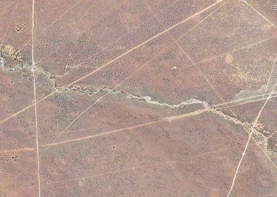
If you look at a satellite image of western Bolivia’s desolate Altiplano plateau, it will appear as if there are thousands of perfectly straight roads criss-crossing each other for no practical reason, stretching for miles and apparently leading to nowhere. Dig deeper, and you’ll discover that these are not roads at all, but white lines etched into the desert sand.
These strange geoglyphs are a network of ancient paths etched into the earth by the indigenous people of the region some 3,000 years ago. They are found near the Nevado Sajama volcano, the highest point in Bolivia. The thousands of individual lines, each three to ten feet in width, are almost perfectly straight mile after mile in spite of the rugged terrain of the highlands—quite a feat for the indigenous people who paved them without modern technology.
Positioned end to end, the Sajama Lines would cover 10,000 miles of terrain, leading many to call the lines the world’s largest work of art. However their exact origins are unknown to this day.
The geoglyphs were most likely created through the process of scraping away the dark oxidized rock on the surface to reveal a lighter surface beneath. The question is, why did these people take the time and effort to pave such seemingly illogical criss-crossing trails? One theory suggests that the lines were forged to serve as footpaths leading to shrines and sacred sites, but this remains unconfirmed. A team of researchers at the University of Pennsylvania is currently investigating the history of the lines, but as of now, their origins remain a mystery.
Related Tags
Know Before You Go
Although it is possible to visit the Sajama Lines in person, perhaps the most comprehensive way to see them is to scan the satellite view of Google Maps. Only then can the true magnitude of the lines, which seem to stretch on to infinity, be witnessed.
Published
October 31, 2017
