Trips Places Foods Stories Newsletters

Take your next trip with Atlas Obscura!

Our small-group adventures are inspired by our Atlas of the world's most fascinating places, the stories behind them, and the people who bring them to life.

Visit Adventures
Trips Highlight
Central Asia yurt night stars
Uzbekistan • 15 days, 14 nights
Central Asia Road Trip: Backroads & Bazaars
from
A view of Brașov’s Old Town.
Romania • 12 days, 11 nights
Legends of Romania: Castles, Ruins & Culinary Delights
from
View all trips
Top Destinations
Latest Places
Most Popular Places Random Place Lists Itineraries
Add a Place
Download the App
Top Destinations
View All Destinations »

Countries

  • Australia
  • Canada
  • China
  • France
  • Germany
  • India
  • Italy
  • Japan

Cities

  • Amsterdam
  • Barcelona
  • Beijing
  • Berlin
  • Boston
  • Budapest
  • Chicago
  • London
  • Los Angeles
  • Mexico City
  • Montreal
  • Moscow
  • New Orleans
  • New York City
  • Paris
  • Philadelphia
  • Rome
  • San Francisco
  • Seattle
  • Stockholm
  • Tokyo
  • Toronto
  • Vienna
  • Washington, D.C.
Latest Places
View All Places »
Side profile of the bomb prototype.
Petwood Hotel Bouncing Bomb
RAF Harrington
RAF Harrington
The Beaux-arts interior with Pool layout still visible.
Écomusée du fier monde
Village du Livre de Fontenoy-la-Joûte
Latest Places to Eat & Drink
View All Places to Eat »
Cacio e pepe lasagna combines two classics.
C'è pasta... E pasta!
Spaghetto taratatà is named for the sound of rattling sabers.
Giano Restaurant
The gnocchi here get blanketed in a sugo with braised oxtail.
Cesare al Pellegrino
Romans insist you should feel the cracked peppercorns and cheese grains on your tongue.
Flavio al Velavevodetto
Tripe is fried to a crisp.
L’Osteria della Trippa
Recent Stories
All Stories Video Podcast
Most Recent Stories
View All Stories »
One of the PATH’s many entrances.
A Supposedly Boring Mall I Might Actually Visit Again
about 12 hours ago
People paddling in their wooden canoes on one of the lakes near the Allagash Waterway in the north woods in Maine
The Allagash Abductions: This State Park’s Most Famous Visitors ... Are Aliens?
1 day ago
The rocky Revere Beach coast in Revere, Massachusetts, just outside Boston.
Which Places With Bad Raps Are Actually Worth Visiting?
3 days ago
A dugong displays the telltale “smile.”
Saving the Sea Cows of Vanuatu
3 days ago

No search results found for
“”

Make sure words are spelled correctly.

Try searching for a travel destination.

Places near me Random place

Popular Destinations

  • Paris
  • London
  • New York
  • Berlin
  • Rome
  • Los Angeles
Trips Places Foods Stories Newsletters
Sign In Join
Places near me Random place
All the United States Utah Thompson Springs Sego Canyon Rock Art
AO Edited

Sego Canyon Rock Art

Thousands of years ago, Indigenous people painted images onto these canyon walls that are still on display today, provocative, mysterious, and enduring reminders of the people who lived here long ago.

Thompson Springs, Utah

Added By
David Hammond
Email
Been Here
Want to go
Added to list
Archaic rock art, Sego Canyon, with possible bullet holes   David Hammond / Atlas Obscura User
Archaic rock art, Sego Canyon   David Hammond / Atlas Obscura User
Fremont rock art, Sego Canyon   David Hammond / Atlas Obscura User
Archaic rock art panel, Sego Canyon   David Hammond / Atlas Obscura User
Ute rock art, Sego Canyon   David Hammond / Atlas Obscura User
8-17-21   Darrell Powers / Atlas Obscura User
Been Here
Want to go
Added to list

About

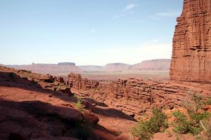
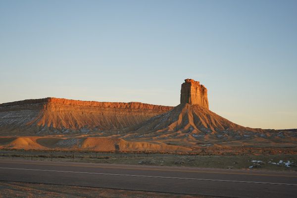
Sego Canyon, Utah, is just west of the Colorado border along U.S. Route 70. During the early twentieth century, a coal-mining town sprang up in the area. When the mining operation failed, the boomtown went bust. Thousands of years before, Indigenous people painted and carved images onto the canyon walls. Those ghostly forms are still on display today, provocative, mysterious, and enduring reminders of the people who lived here long ago.

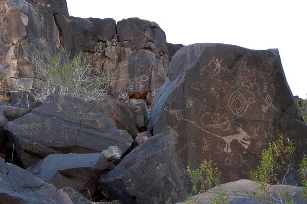
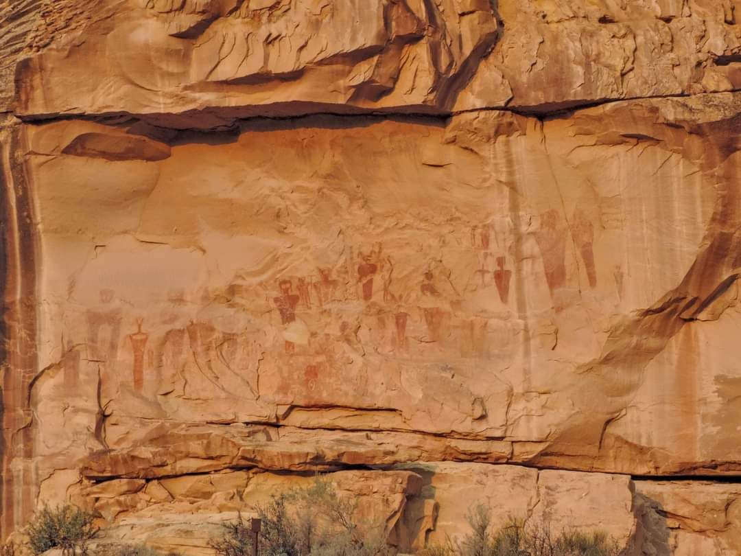
Rock art on the walls of Sego Canyon was created over the centuries by three distinct tribal groups who lived in the area: the Utes, Fremont, and Archaic peoples. In the parking lot, on the western and northern walls, you can see petroglyphs (art made by picking or scratching the stone walls) and pictographs (paintings).

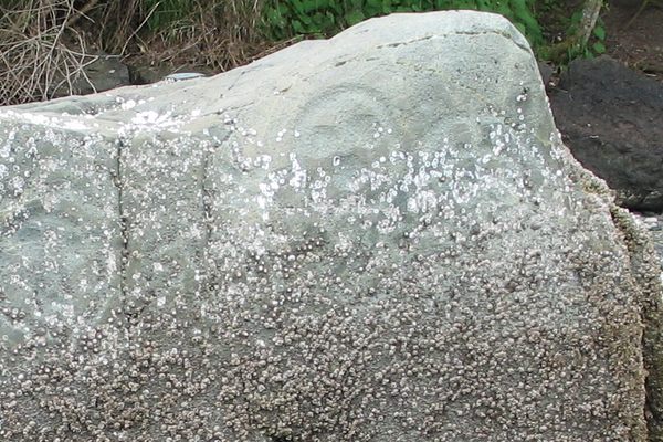
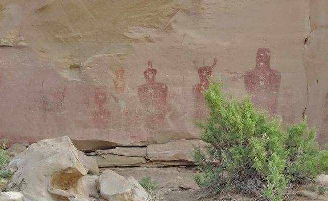
On the western wall, just opposite the entrance to the parking lot, are pictographs attributed to the Ute, the indigenous tribe that gave Utah its name. These paintings include pictures of horses, which means the artwork must have been created after 1493, when Christopher Columbus made his second voyage to the Americas and brought horses, which were previously unknown in what is now North America and South America. The pale white circles are shields and may function as symbolic declarations of real estate ownership: “this is the land of the Utes.” Though these are the most recent rock art creations in the area, they also seem to be the most crudely rendered. Living in this part of the world until around 1880, the Utes were eventually forced onto reservations.

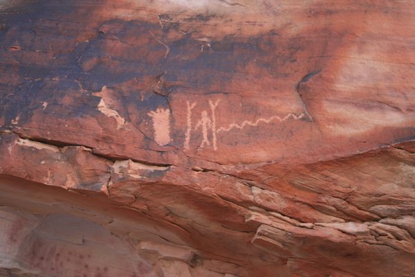
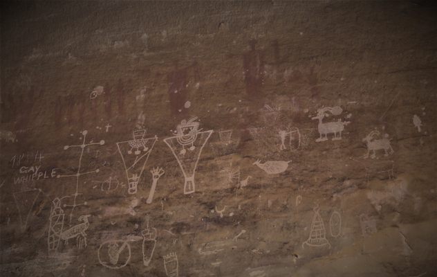
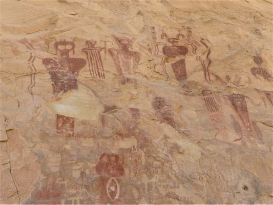
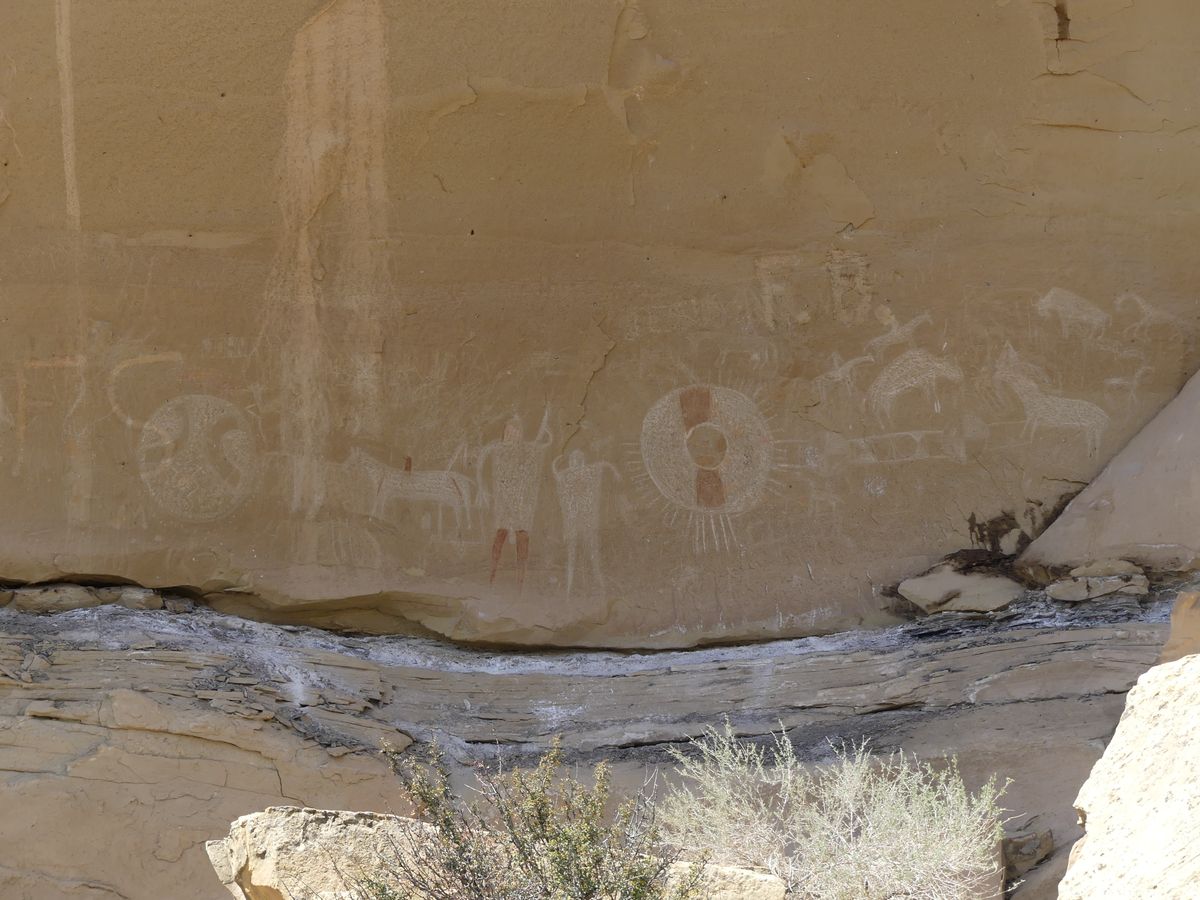
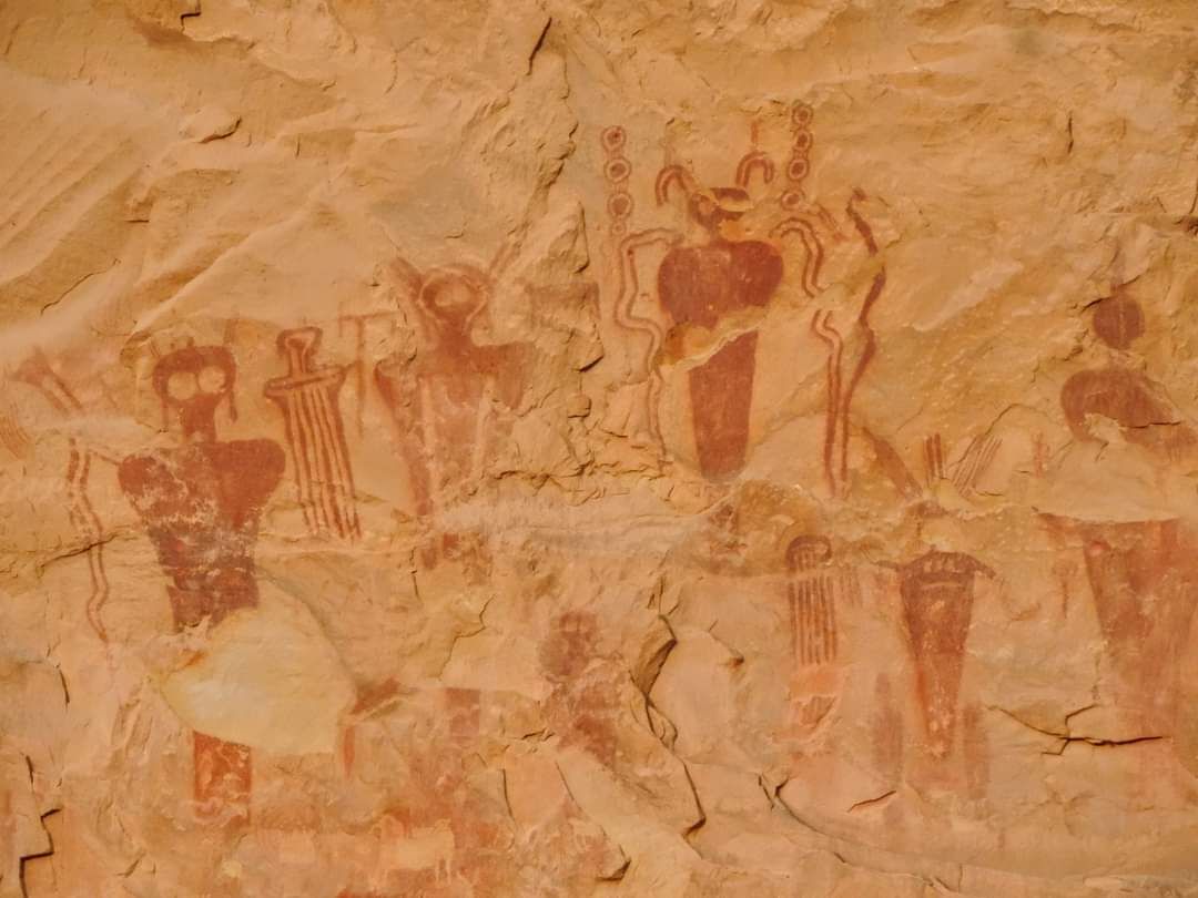
On the northern wall facing the parking lot are petroglyphs attributed to the Fremont people who lived in Utah, Idaho, Colorado, and Nevada from the first until the 14th century. These images, scratched onto the canyon walls, contain characteristic Fremont features including longhorn sheep and anthropomorphic figures with trapezoidal and armless upper bodies and some facial definition (e.g., mouths). The heads are sometimes decorated with headgear and jewelry. In the photo of the Fremont rock art, you can see the ghostly reddish images of even older, perhaps Archaic, pictographs; of most interest are two on the upper center and left of center, from whose outstretched arms descend vertical lines, likely indicating rain (which is rare in the desert, which is why these figures may be objects of supplication: the beings you beseech—or thank—for rain).

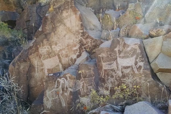
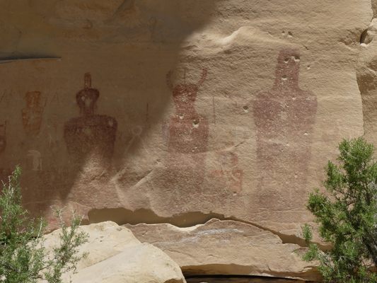
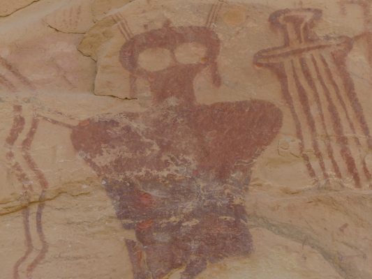
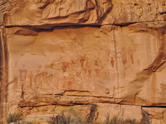
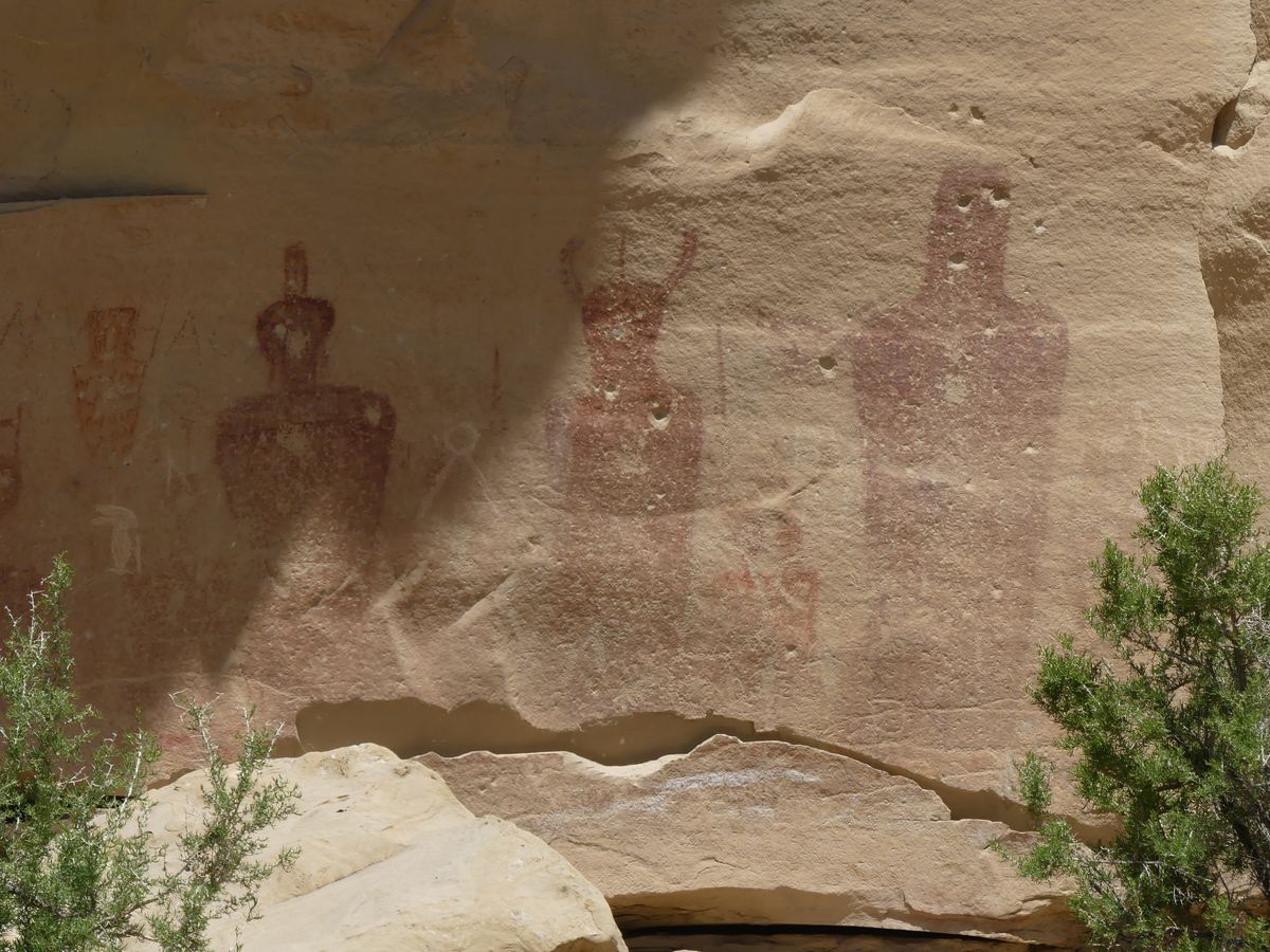
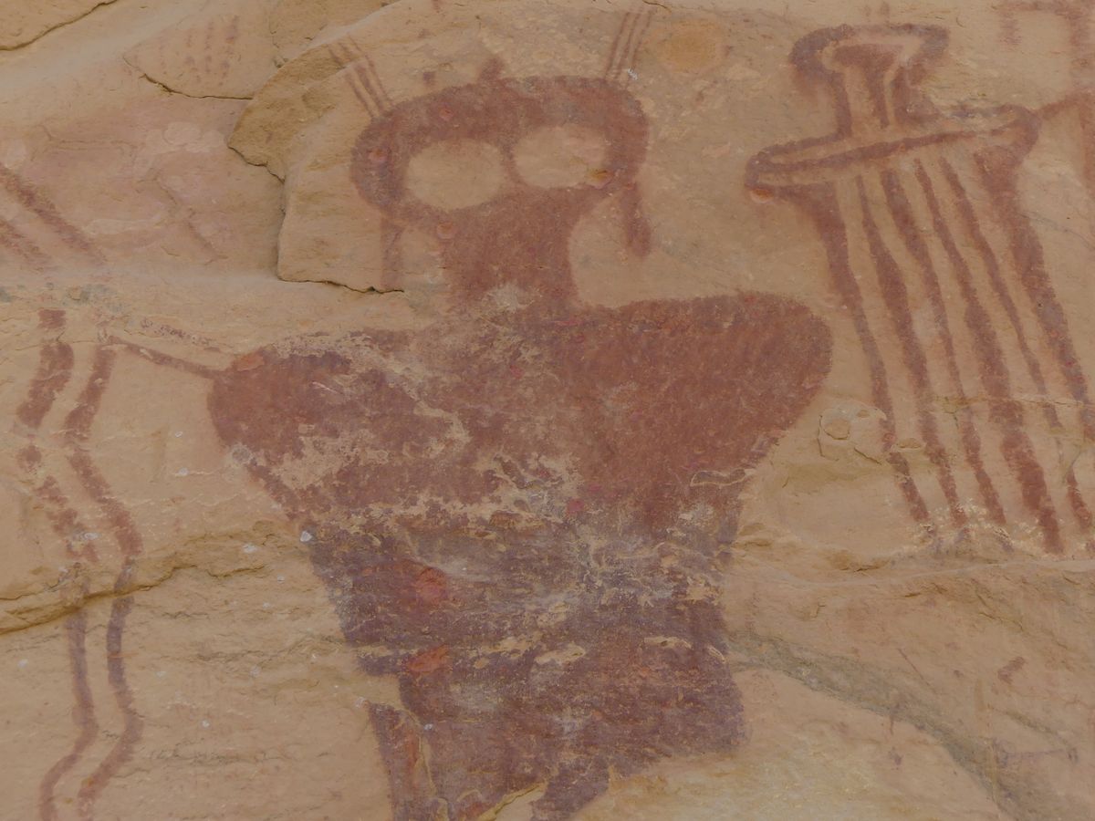
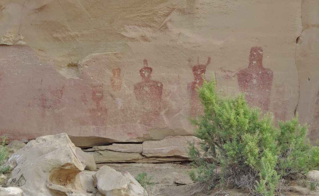
Walk around this northern wall of the parking lot to see some of the most stunning pictographs in Utah. These paintings, in what’s called Barrier Canyon Style, are attributed to the Archaic people of this region, and the dates for these ancient peoples have been estimated to be as early as 8,000 B.C. until around 1,000 A.D. It is exceedingly difficult to date such old rock paintings, though it may be possible to carbon-date some of the materials in the paint itself, and one can roughly estimate dates based on the amount of patination, the discoloration that results when “rock varnish” creates dark stains on the rock face and the figures.

Barrier Canyon Style is exemplified by the artwork of Sego Canyon and the Great Gallery in the Mazes section of Canyonlands National Park, which used to be called Barrier Canyon but is now called Horseshoe Canyon. Barrier Canyon Style is characterized by ghostly figures, painted without arms, legs, or facial features. They look a little like mummies. The “googly eyes” of the figures could represent the empty eye sockets of skulls, or perhaps this is a connection with the google-eyed rain gods Tlaloc of the Aztec and Chac of the Maya. The many vertical lines on this rock art painting may also represent rain.

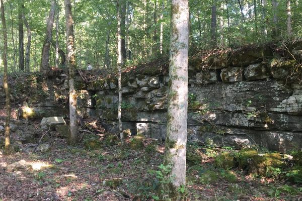
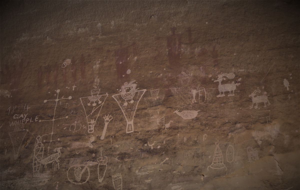
Across the road from these incredible artworks are the broken remnants of the now-defunct coal mining operation. On these canyon walls, which are now enclosed in barbed wire, you will find more ghostly figures, with holes in the areas of head and heart, suggesting they may have been used for target practice. Such disrespect for the artistic works and sacred objects of our collective patrimony is not uncommon, as further evidenced by the names and other graffiti scrawled onto these ancient images, acts of vandalism that are now, alas, part of the enduring archaeological record of rock art in Sego Canyon.

Related Tags

Petroglyphs Indigenous Native Americans Ancient Mining

Know Before You Go

After passing Cisco on U.S. 70 out of Colorado, take the Thompson Springs exit (187), and follow Thompson Canyon Road through the broken-down buildings that lead onto Sego Canyon Road; then go north for about one-tenth of a mile to the parking lot, which is next to the walls of rock art explained above.

Community Contributors

Added By

David Hammond

Edited By

Darrell Powers

  • Darrell Powers

Published

June 21, 2021

Edit this listing

Make an Edit
Add Photos
Sego Canyon Rock Art
21 Sego Cyn Rd #104
Thompson Springs, Utah, 84540
United States
39.023013, -109.710704
Visit Website
Get Directions

Nearby Places

Sego, Utah

Thompson, Utah

miles away

Landscape Arch

Moab, Utah

miles away

Tusher Tunnel

Moab, Utah

miles away

Explore the Destination Guide

Photo of Utah

Utah

United States

Places 155
Stories 29

Nearby Places

Sego, Utah

Thompson, Utah

miles away

Landscape Arch

Moab, Utah

miles away

Tusher Tunnel

Moab, Utah

miles away

Explore the Destination Guide

Photo of Utah

Utah

United States

Places 155
Stories 29

Related Stories and Lists

The Mysterious Petroglyphs and Twisted Towers Beyond Utah’s National Parks

List

Sponsored by Visit Utah

Related Places

  • 8 foot tall Owl Rock

    Atlanta, Georgia

    Owl Rock

    This Native American petroglyph marks the location of an important, Creek trail.

  • On the platform.

    Lovelock, Nevada

    Lovelock Cave

    How a bat poo mine became a major Native American archaeological site—and connections to legendary red-haired giants.

  • Big Foot petroglyph, with standing figure to right.  The Big Foot is literally a representation of a bare human footprint, not the storied cryptid.

    Clark County, Nevada

    Black Butte Petroglyph Trail

    The highest concentration of petroglyph sites in Gold Butte National Monument, plus an improbable early 20th-century dam.

  • Ute Mountain Chimney Rock

    Towaoc, Colorado

    Ute Mountain Tribal Park

    Ute tour guides have been sharing the ancient dwellings and rock art inside this large park with visitors for more than 40 years.

  • Petroglyphs at Sears Point

    Dateland, Arizona

    Sears Point Petroglyphs

    Some 10,000 works of ancient rock art cover these volcanic basalt outcrops near the Gila River.

  • Ruins of the Old Stone Fort walls.

    Manchester, Tennessee

    Old Stone Fort

    This limestone outcropping was once a ceremonial site for ancient Native Americans.

  • Inyo County, California

    Coso Rock Art District

    A mountain range on an active U.S. Navy base hides thousands of mysterious prehistoric rock carvings.

  • Petroglyphs visible on Haleets Rock.

    Bainbridge Island, Washington

    Haleets Rock

    Mysterious ancient petroglyphs carved on a glacial boulder at the tip of Bainbridge Island.

Aerial image of Vietnam, displaying the picturesque rice terraces, characterized by their layered, verdant fields.
Atlas Obscura Membership

Become an Atlas Obscura Member


Join our community of curious explorers.

Become a Member

Get Our Email Newsletter

Follow Us

Facebook YouTube TikTok Instagram Pinterest RSS Feed

Get the app

Download the App
Download on the Apple App Store Get it on Google Play
  • All Places
  • Latest Places
  • Most Popular
  • Places to Eat
  • Random
  • Nearby
  • Add a Place
  • Stories
  • Food & Drink
  • Itineraries
  • Lists
  • Video
  • Podcast
  • Newsletters
  • All Trips
  • Family Trip
  • Food & Drink
  • History & Culture
  • Wildlife & Nature
  • FAQ
  • Membership
  • Feedback & Ideas
  • Community Guidelines
  • Product Blog
  • Unique Gifts
  • Work With Us
  • About
  • FAQ
  • Advertise With Us
  • Advertising Guidelines
  • Privacy Policy
  • Cookie Policy
  • Terms of Use
Atlas Obscura

© 2025 Atlas Obscura. All Rights Reserved.