About
In the state of Nevada, almost exactly dead center, there is a cave lined with colorful pictographs. The site sits high on Pete’s Summit near the tiny town of Austin, inside the Humboldt-Toiyabe National Forest. There’s a history of gold and silver prospecting around here, but to the Western Shoshone people its purpose has little to do with shiny metals.
Located in the Toquima Mountain Range, these remote and rocky hills are full of bighorn sheep, golden eagles, and a chubby partridge called a chukar. The cave is also called Toquima (both are named for a tribe from the lower Reese River valley), and it has nourished deep spiritual roots for Native Americans for millennia.
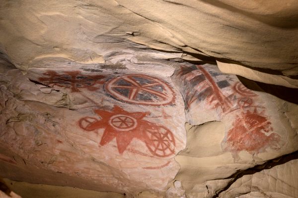
The pictographs on the cave walls were painted by hand, thousands of years ago, using pigments of bleached white, bright red, and a yellowy turmeric orange. Unlike petroglyphs (you can see some of those here, here and here), the images are not carved into the rock but added to the surface, most likely with fingers, in circular, cross-hatched, and beautiful snaking patterns.
The images, over three hundred in all, date from around 1000 B.C. to 500 A.D., a time of hunter-gatherers in the Americas. The cave depth is fairly shallow, so if it was used as a dwelling it was probably short-term, an archaeological conclusion bolstered by the lack of artifacts that have been excavated here (you can see a cave that was used more for “storage” at Hidden Cave in Fallon, Nevada, about 100 miles due west). Given the sweeping views from the cliff, the site may have instead been used as a place-marker or geographical guide post for finding food sources, tracking hunting grounds or managing other tribal movements.
Deciphering the images has been a challenge undertaken by archeologists and anthropologists alike, but specific answers to their meaning have been elusive. They may be keys to the land or, as some have posited, keys to other, less worldly, places. Caves shelters are seen as portals by some Native peoples, providing access to commune with the earth, experience visions, and to seek understanding of what lies beyond.
Whether used for the temporal or spiritual world, Toquima Cave and the pictographs hold great power for the Western Shoshone, and when visiting it’s important to remember and revere that power–of the earth, of the Native cultures of central Nevada, and of the symbols left behind by ancient stained fingers.
Related Tags
Know Before You Go
The cave is at Pete’s Summit in the Toquima Mountain Range, about a 30-mile southeast of Austin, Nevada. Starting on US-50 east, follow the highway for about 11 miles to NV-376 south, and turn right. After a third of a mile you’ll see a Historic marker on your left. Turn left here so you’re heading east on the dirt road. It’s then about 19 bumpy miles to Pete’s Summit and the Toquima Cave Campground. The hike is half a mile or so from the campground. The cave is fairly shallow, so the fencing, although keeping you from getting too close to the images, is for the protection of the cave. But you can see inside very well, and there are still good photo ops. Most importantly, remember this is a sacred site. This is a time to "take nothing but pictures, and leave nothing but footprints."
Published
February 15, 2017
Sources
- http://travelnevada.com/discover/31134/toquima-cave
- https://en.wikipedia.org/wiki/Toquima_Cave
- http://austinnevada.com/plenty-to-see-and-do/rock-art/
- http://www.fs.usda.gov/Internet/FSE_DOCUMENTS/fsbdev3_014880.pdf
- http://travelnevada.com/adventures/31191/practice-safe-hot-springing-just-dont-forget-condiments


