Trips Places Foods Stories Newsletters

Take your next trip with Atlas Obscura!

Our small-group adventures are inspired by our Atlas of the world's most fascinating places, the stories behind them, and the people who bring them to life.

Visit Adventures
Trips Highlight
Puglia Italy - Matera
Italy • 8 days, 7 nights
Southern Italy: Castles, Caves & Coastal Treasures in Puglia
from
Turkmenistan Gates of Hell Darvaza crater
Turkmenistan • 10 days, 9 nights
Turkmenistan & the Gates of Hell
from
View all trips
Top Destinations
Latest Places
Most Popular Places Random Place Lists Itineraries
Add a Place
Download the App
Top Destinations
View All Destinations »

Countries

  • Australia
  • Canada
  • China
  • France
  • Germany
  • India
  • Italy
  • Japan

Cities

  • Amsterdam
  • Barcelona
  • Beijing
  • Berlin
  • Boston
  • Budapest
  • Chicago
  • London
  • Los Angeles
  • Mexico City
  • Montreal
  • Moscow
  • New Orleans
  • New York City
  • Paris
  • Philadelphia
  • Rome
  • San Francisco
  • Seattle
  • Stockholm
  • Tokyo
  • Toronto
  • Vienna
  • Washington, D.C.
Latest Places
View All Places »
Pinal Airpark
Note the chrysanthemum crests.
Hachiman Bridge
Clarendon War Memorial.
Clarendon War Memorial
This fried chicken is one of Bangkok’s most famous.
Gai Tord Jae Kee
Latest Places to Eat & Drink
View All Places to Eat »
This fried chicken is one of Bangkok’s most famous.
Gai Tord Jae Kee
Chefs Aruss Lerlerstkull and Atcharaporn Kiatthanawat lean into regional traditions.
Charmgang
The khao soi at Gedhawa comes with a rich, coconutty broth.
Gedhawa
At Nai Mong Hoi Thod, the oyster omelet is worth waiting for.
Nai Mong Hoi Thod
In this deceptively simple dish, top-quality ingredients are paramount.
Kor Panich
Recent Stories
All Stories Video Podcast
Most Recent Stories
View All Stories »
Haleakalā National Park’s summit region, shrouded in the pre-dawn fog.
Beware the Legends Behind These National Park Souvenirs
1 day ago
For Aguilar-Carrasco, nature is a powerful reminder of the interconnectedness of all life.
How Can National Parks Be Made Accessible to All? AO Wants to Know.
2 days ago
Podcast: Finding ‘The Great Gatsby’ in Louisville
3 days ago
Here’s which treats you can safely lug home without risking a fine.
Dear Atlas: What International Food Can I Legally Bring Into the U.S.?
4 days ago

No search results found for
“”

Make sure words are spelled correctly.

Try searching for a travel destination.

Places near me Random place

Popular Destinations

  • Paris
  • London
  • New York
  • Berlin
  • Rome
  • Los Angeles
Trips Places Foods Stories Newsletters
Sign In Join
Places near me Random place
All the United States Nevada Austin Toiyabe Crest Trail
AO Edited

Toiyabe Crest Trail

This little-used trail winds through the highest mountain range in central Nevada with sections around 10,000 feet.

Austin, Nevada

Added By
slgwv
Email
Been Here
Want to go
Added to list
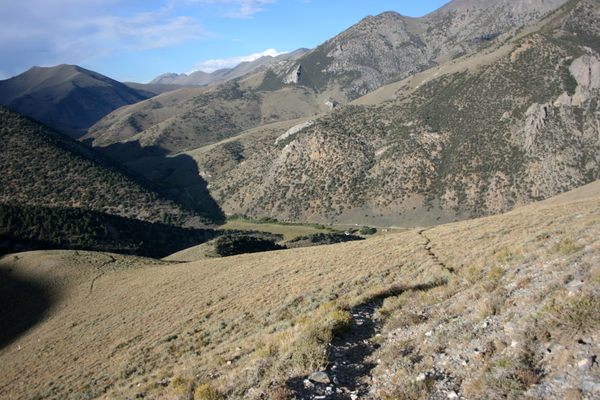
On the Toiyabe Crest Trail in South Twin River Canyon, looking downstream. Arc Dome Wilderness.   slgwv / Atlas Obscura User
Toiyabe Crest trail in South Twin River Canyon.   slgwv / Atlas Obscura User
Stone steps on the Toiyabe Crest Trail, just past the junction of the South Fork Twin River Trail, Arc Dome Wilderness.   slgwv / Atlas Obscura User
Toiyabe Crest Trail topping out between Columbine Creek and North Twin River, in the Arc Dome Wilderness Elevation at this saddle is a little less than 10,600 ft (3231 m). Looking south; note the snow patches lingering into July! Arc Dome itself (11,776 ft/3588 m) is hidden behind the skylined ridge.   slgwv / Atlas Obscura User
Toiyabe Crest Trail in the upper reaches of the south fork of San Juan Creek, looking south.   slgwv / Atlas Obscura User
Toiyabe Crest Trail in the upper reaches of San Juan Creek, looking north.   slgwv / Atlas Obscura User
On the Toiyabe Crest Trail, looking north over the headwaters of Washington Creek.   slgwv / Atlas Obscura User
View westward from the Toiyabe Crest Trail above Brewer Canyon, looking over the Reese River Valley to the Shoshone Range.   slgwv / Atlas Obscura User
The Toiyabe Crest Trail where it first tops out above the Kingston Canyon trailhead. Elevation here is about 9100 ft/2774 m. Looking south.   slgwv / Atlas Obscura User
Arc Dome (11,773 ft/3588 m), centerpiece of the eponymous wilderness area, as seen from the Toiyabe Crest Trail.   slgwv / Atlas Obscura User
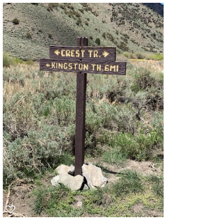
New (June 2021) trail sign in Kingston Canyon   birdynumnumz / Atlas Obscura User
Looking up South Twin River after topping out over the ridge at the mouth of the canyon. Arc Dome Wilderness.   slgwv / Atlas Obscura User
Ruin of a water wheel at an old mining site, in South Twin River Canyon, Arc Dome Wilderness. This is right on the trail.   slgwv / Atlas Obscura User
Where the (here) vaguely-defined Toiyabe Crest Trail joins the Columbine trail in the Arc Dome Wilderness. Looking north. Elevation here is about 10,200 ft/3109 m.   slgwv / Atlas Obscura User
Stone retaining wall, above the south fork of San Juan Creek.   slgwv / Atlas Obscura User
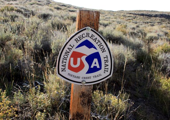
An official sign!   slgwv / Atlas Obscura User
Toiyabe Crest Trail looking north, back down into Kingston Canyon. The Kingston Canyon road, with some vehicles parked by Groves Lake, is visible just right of center. The trailhead is off in the shadowed area to the left, at the bottom of the canyon.   slgwv / Atlas Obscura User
Been Here
Want to go
Added to list

About

The National Recreation Trails are a U.S. national resource—and most of them get used accordingly, complete with guidebooks, mileage logs, notes on campsites and water sources, and so on. In popular wilderness areas you even need to reserve a campsite. That's fun, but not quite the wilderness experience. But one trail in that system that's not crowded is the Toiyabe Crest Trail. It gets so little use, it's advised you bring topographic maps in case you need to route-find.

The Toiyabe (toy-YAH-bee) Crest Trail runs along the Toiyabe Range for over 70 miles. This range stretches north-south for some 120 miles, with its highest peaks over 11,000 feet (approximately 3,350 meters), right in the middle of Nevada. The trail extends from South Twin River in the Arc Dome Wilderness at the south to Kingston Canyon at the north. It largely lies in the Humboldt-Toiyabe National Forest, and even though the only designated wilderness is at the south end, most of the area is effectively wilderness.

The trail was built by the Civilian Conservation Corps in the 1930s, when the area was really the back-of-beyond. Here and there you can see some rock walls and steps that are still preserved. The range is much drier than the Sierra Nevada, but there are some perennial streams in the lower elevations; all water should be treated, and enough carried! Snow can also linger in the higher elevations into summer.

Only experienced hikers should attempt this trail. An emergency satellite beacon is strongly recommended; if you have trouble you're unlikely to meet any other hikers. It probably doesn't need to be said, though, that if you want the true wilderness experience, this is it! Sweeping views, sublime stillness, the sense of having the whole planet all to yourself—it's all here.

Related Tags

Trails Hiking Mountains

Know Before You Go

The north and south trailheads, in Kingston Canyon and at the mouth of South Twin River respectively, are accessed by graded roads that should be passable in dry weather to ordinary passenger cars. For Kingston Canyon, turn west off Nevada SR 376 (Big Smoky Valley highway) on the Kingston Canyon road and follow it through the village of Kingston, where it turns into US Forest Service road 002. The trailhead is on the left, past Groves Reservoir, about 5 miles past the end-of-pavement. There is a US Forest Service campground about halfway along, but there is no longer lodging available in Kingston itself. To get to the South Twin River trailhead, take USFS road 080 west off SR 376.   (This trailhead is shown as the address.)  This road makes a loop; the southern part of the loop is usually in better repair. As of this writing no permit is required for the Arc Dome Wilderness, either for camping or day use.

Intermediate trail access is possible in a few places, but requires a four-wheel-drive high-clearance vehicle, and significant hiking will still usually be required to reach the trail proper from the end of the road. Consult the topographic maps. The Forest Service has versions of the US Geological Survey 7.5' quadrangle maps available online as pdf files. They're the most useful versions because they're both current and show the USFS route numbers.

Community Contributors

Added By

slgwv

Edited By

Vaquero, birdynumnumz

  • Vaquero
  • birdynumnumz

Published

May 24, 2021
Edit this listing

Make an Edit
Add Photos
Sources
  • https://travelnevada.com/hiking/toiyabe-crest-national-recreation-trail-arc-dome-wilderness/
Toiyabe Crest Trail
Kingston Canyon Rd
Austin, Nevada, 89310
United States
39.24223, -117.166249
Visit Website
Get Directions

Nearby Places

U.S. Route 50

Austin, Nevada

miles away

Stokes Castle

Austin, Nevada

miles away

Toquima Cave

Austin, Nevada

miles away

Explore the Destination Guide

Photo of Austin

Austin

Nevada

Places 7

Nearby Places

U.S. Route 50

Austin, Nevada

miles away

Stokes Castle

Austin, Nevada

miles away

Toquima Cave

Austin, Nevada

miles away

Explore the Destination Guide

Photo of Austin

Austin

Nevada

Places 7

Related Places

  • The view of the Blue Ridge Mountains here is spectacular.

    Canton, North Carolina

    Black Balsam Knob

    On a clear afternoon, you can see mountain peaks more than 40 miles away from this clearing in the Pisgah National Forest.

  • Looking north along Winter Ridge.  Summer Lake on the right.

    Paisley, Oregon

    Fremont National Recreation Trail

    A remote trail traverses the little-known Gearhart Mountains of southern Oregon.

  • Peter Grubb Hut

    Norden, California

    Peter Grubb Hut

    This trailside hut was built in the late 1930s as a memorial to a young hiker.

  • Sunset at Morro do Pai Inácio

    Palmeiras, Brazil

    Morro do Pai Inácio

    This peak in Chapada Diamantina National Park offers the most stunning sunsets.

  • Ensign Peak

    Salt Lake City, Utah

    Ensign Peak

    In 1847, Brigham Young climbed this hill to survey the Salt Lake Valley and saw a fine place to build a city.

  • Eden, Utah

    Paper Airplane Trail

    This massive metal sculpture in the shape of a folded paper airplane overlooks a Utah mountain.

  • Indian Canyons

    Palm Springs, California

    Indian Canyons

    Traversing these canyons, visitors can take in stunning views and glimpses of the region's history.

  • The Herrick Sawmill

    Florence, Colorado

    Herrick Sawmill

    An abandoned sawmill from more than 134 years ago stands testament to the ambition of one man.

Aerial image of Vietnam, displaying the picturesque rice terraces, characterized by their layered, verdant fields.
Atlas Obscura Membership

Become an Atlas Obscura Member


Join our community of curious explorers.

Become a Member

Get Our Email Newsletter

Follow Us

Facebook YouTube TikTok Instagram Pinterest RSS Feed

Get the app

Download the App
Download on the Apple App Store Get it on Google Play
  • All Places
  • Latest Places
  • Most Popular
  • Places to Eat
  • Random
  • Nearby
  • Add a Place
  • Stories
  • Food & Drink
  • Itineraries
  • Lists
  • Video
  • Podcast
  • Newsletters
  • All Trips
  • Family Trip
  • Food & Drink
  • History & Culture
  • Wildlife & Nature
  • FAQ
  • Membership
  • Feedback & Ideas
  • Community Guidelines
  • Product Blog
  • Unique Gifts
  • Work With Us
  • About
  • FAQ
  • Advertise With Us
  • Advertising Guidelines
  • Privacy Policy
  • Cookie Policy
  • Terms of Use
Atlas Obscura

© 2025 Atlas Obscura. All Rights Reserved.