About
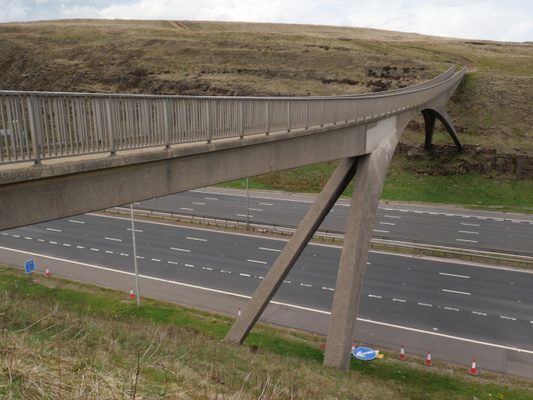
The most obvious of the features of the long Windy Hill cutting on the M62 is the elegant and narrow parabolic arched bridge that sweeps overhead. In a display of pedestrian power, it's there to carry the remote and rugged Pennine Way across the motorway.
The bridge itself is designed to cope with wind speeds up to 120 mph (it's called Windy Hill for a reason), although you'd hope that the hikers had retired to the pub long before it got to that point.
Between the 300 and 200 yard markers for J22 eastbound, there's an unusual cairn on the other side of the barrier, marked with a white rose and a plaque. A matching one on the opposite carriageway has a red rose. These stones mark the boundary between Greater Manchester and West Yorkshire. They date from the Queen's visit in 1971 to cut a ribbon to officially open the Pennine stretch of the motorway. The text reads: "This plaque marks the boundary between the counties of Lancaster and York and was unveiled by THE QUEEN on the occasion of Her Majesty's visit to the Lancashire Yorkshire motorway M62 on the 14th October 1971."
At the lay-by on the A672 next to the Windy Hill transmitter, there's a random assortment of municipal boundary signs from different eras. From there you can walk along a section of the Pennine Way and cross the footbridge, where the marker stones are visible in the distance.
Further east on the M62 is Stott Hall Farm, the famous house in the middle of the motorway.
Related Tags
Know Before You Go
Stopping to look at the cairns would be illegal and dangerous. The best way of inspecting them is via Google Street View.
To get to the footbridge, take the A672 towards Oldham. The lay-by is just past the transmitter. Pick up the Pennine Way on the same side of the road and follow it to the footbridge. The red marker stone is visible in the distance on the lefthand side
Community Contributors
Added By
Published
June 29, 2021


