Trips Places Foods Stories Newsletters

Take your next trip with Atlas Obscura!

Our small-group adventures are inspired by our Atlas of the world's most fascinating places, the stories behind them, and the people who bring them to life.

Visit Adventures
Trips Highlight
A view of Brașov’s Old Town.
Romania • 12 days, 11 nights
Legends of Romania: Castles, Ruins & Culinary Delights
from
Balkans road trip
Bosnia and Herzegovina • 9 days, 8 nights
Balkans Road Trip: Serbia, Croatia & Bosnia and Herzegovina
from
View all trips
Top Destinations
Latest Places
Most Popular Places Random Place Lists Itineraries
Add a Place
Download the App
Top Destinations
View All Destinations »

Countries

  • Australia
  • Canada
  • China
  • France
  • Germany
  • India
  • Italy
  • Japan

Cities

  • Amsterdam
  • Barcelona
  • Beijing
  • Berlin
  • Boston
  • Budapest
  • Chicago
  • London
  • Los Angeles
  • Mexico City
  • Montreal
  • Moscow
  • New Orleans
  • New York City
  • Paris
  • Philadelphia
  • Rome
  • San Francisco
  • Seattle
  • Stockholm
  • Tokyo
  • Toronto
  • Vienna
  • Washington, D.C.
Latest Places
View All Places »
The Sea Water Distilling Plant.
Sea Water Distilling Plant
Contemplative paths.
Ayo Rock Formations
Parking Lot Shoeprints
Dewey Square Pylon & Bent 38
Latest Places to Eat & Drink
View All Places to Eat »
The pavlova comes crowned with jewel-like fruit.
Central Park Boathouse
The Village Tavern of Long Grove - exterior.
The Village Tavern
Hunter House Hamburgers
L’Escamoteur
Names on the bartop.
The Dive
Recent Stories
All Stories Video Podcast
Most Recent Stories
View All Stories »
Alresford Spy Toilet
This Public Bathroom in a Sleepy English Village Was an Epicenter for Cold War Espionage
2 days ago
Manhattan Well
The Manhattan Well: How Aaron Burr and Alexander Hamilton United to Solve a Murder Mystery
3 days ago
Beneath downtown Minneapolis, Schieks Cave has surprisingly warm groundwater, evidence of a subterranean heat island.
Schieks Cave Below Minneapolis Contains a Lake of Warm Sewage
4 days ago
Athenaeus described various kinds of Greek drinking vessels, like the deep, rounded skyphos and wide, flat kylix.
The Ancient Greek Guide to Succeeding at Dinner Parties
5 days ago

No search results found for
“”

Make sure words are spelled correctly.

Try searching for a travel destination.

Places near me Random place

Popular Destinations

  • Paris
  • London
  • New York
  • Berlin
  • Rome
  • Los Angeles
Trips Places Foods Stories Newsletters
Sign In Join
Places near me Random place
All the United States Ohio Cincinnati Cincinnati Yellow Lamps

Cincinnati Yellow Lamps

An obsolete, vanishing traffic device warns Cincinnati drivers away from middle-of-the-road obstructions.

Cincinnati, Ohio

Added By
cbfellerhoff
Email
Been Here
Want to go
Added to list
Island Lamp at night, intersection of Madison Road and Edwards Road   cbfellerhoff / Atlas Obscura User
Detail of Yellow Lamp globe and canopy   cbfellerhoff / Atlas Obscura User
Island Lamps at intersection of Victory Parkway and Gilbert Avenue   cbfellerhoff / Atlas Obscura User
Island Lamp at night, intersection of Columbia Parkway and Torrence Parkway   cbfellerhoff / Atlas Obscura User
Been Here
Want to go
Added to list

About

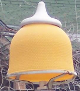
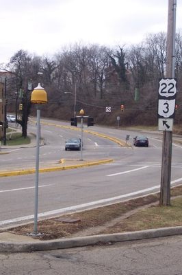
Found only (as the name would suggest) in the City of Cincinnati, the Cincinnati Yellow Lamps are a distinctive but easily overlooked feature of the city's streetscape. Known officially as "Island Lights" and often colloquially referred to as "Turtle Lamps," the devices were installed to alert drivers to the presence of raised islands within the roadway.

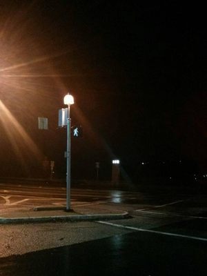
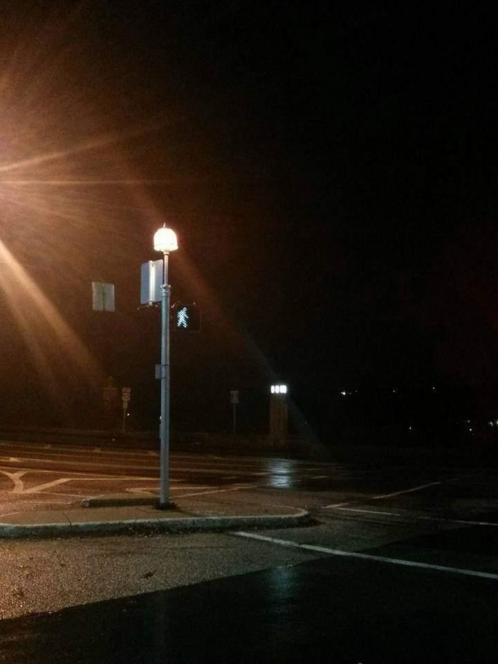
The lamps are known for their distinctive shape and color; the yellow glass globe resembles a bell, fanciful helmet, or turtle shell (hence the nickname), and is adorned with a spun aluminum canopy that resembles a slightly-squished chocolate kiss.

Some residents and local authorities trace the lamps' origin to markers for streetcar platforms that were situated in the middle of roadways. This claim is bolstered by the fact that the yellow color matches the color branding of the last of Cincinnati's early 20th-century streetcar lines. However, photos of streetcar platforms show a different type of lamp, casting doubt on this assertion.

The current lamps can indicate any elevated median in a roadway within the city limits, including either a center island or a corner "pork chop" island associated with a channelized right turn lane.

The fragility, high replacement cost, and non-critical function of the Cincinnati Yellow Lamps leave them slated for obsolescence, with reports claiming that the city will no longer replace them when they fall or get damaged. However, after a lamp fell in August of 2014 and was salvaged by a local lamp enthusiast (thinking it was destined for the scrap heap) and turned into a floor lamp, the enthusiast community was surprised to find the fallen lamp replaced a few weeks later.

A "Cincinnati Yellow Lamps" Facebook group receives photos and other reports of existing and former lamp locations and has close to 300 followers. The group has also compiled a Google map of over 50 existing lamps and 15 former lamp locations found throughout the city.

Related Tags

Roads Automotive History Transportation Cities

Know Before You Go

Drive around the major thoroughfares of Cincinnati and look in any raised median. At night, keep your eyes open for the distinctive amber glow. Or consult the Google map included in the sources below for precise locations.

Community Contributors

Added By

cbfellerhoff

Edited By

RHyzer

  • RHyzer

Published

November 28, 2016

Edit this listing

Make an Edit
Add Photos
Sources
  • http://www.cincinnati.com/story/news/your-watchdog/2014/04/14/turtle-lights-dimming-destined-extinction/7725759/
  • http://www.urbanohio.com/forum2/index.php?topic=26140.0
  • https://www.google.com/maps/d/viewer?mid=1UTWEQxQRygsitsjfi-_21u3N5kI&ll=39.11955852866736%2C-84.50450310000002&z=12
  • https://www.facebook.com/CincinnatiYellowLamps/
Cincinnati Yellow Lamps
Cincinnati, Ohio
United States
39.10645, -84.51928

Nearby Places

The Betts House

Cincinnati, Ohio

miles away

Ezzard Charles' Former Boxing Gym

Cincinnati, Ohio

miles away

Cincinnati Mercantile Library

Cincinnati, Ohio

miles away

Explore the Destination Guide

Photo of Cincinnati

Cincinnati

Ohio

Places 16
Stories 6

Nearby Places

The Betts House

Cincinnati, Ohio

miles away

Ezzard Charles' Former Boxing Gym

Cincinnati, Ohio

miles away

Cincinnati Mercantile Library

Cincinnati, Ohio

miles away

Explore the Destination Guide

Photo of Cincinnati

Cincinnati

Ohio

Places 16
Stories 6

Related Places

  • National Route 66 Museum

    Elk City, Oklahoma

    National Route 66 Museum

    An Oklahoma museum that celebrates the history of the "Mother Road."

  • The Old Plank Road.

    Winterhaven, California

    Old Plank Road

    The remnants of an early automobile route across shifting sand dunes can still be found in the deserts of Southern California.

  • Bell at Mission Santa Inez

    San Luis Obispo, California

    The Bells of El Camino Real

    A chain of bells connect the California Missions and honor the legend of the "King’s Highway."

  • Come journey into the feudal past.

    Hakone, Japan

    Old Tokaido Way

    The centuries-old cobblestones of a feudal highway remain in the woods of Hakone.

  • Looking down Lake Como road at sunset

    Blanca, Colorado

    Lake Como Road

    The worst road in Colorado is the main gateway to some of its highest peaks.

  • Brussels, Belgium

    Largest Paving Stone in Belgium

    This huge limestone slab is considered the largest paving stone in Belgium and a relic of the earliest modern paving in Brussels.

  • Looking south not far from Caliente.  The paved path to the right of the highway connects Caliente with Kershaw-Ryan State Park and is open to non-motorized traffic.

    Etna, Nevada

    Meadow Valley Wash

    Much of the spectacular canyon followed over a century ago by the Los Angeles & Salt Lake railroad is now accessible to cars.

  • Swales (wagon ruts) at Lobanillo Swales

    Bronson, Texas

    Lobanillo Swales

    The preserved wheel ruts of El Camino Real de los Tejas, an 18th-century Spanish colonial road across America's Southwest.

Aerial image of Vietnam, displaying the picturesque rice terraces, characterized by their layered, verdant fields.
Atlas Obscura Membership

Become an Atlas Obscura Member


Join our community of curious explorers.

Become a Member

Get Our Email Newsletter

Follow Us

Facebook YouTube TikTok Instagram Pinterest RSS Feed

Get the app

Download the App
Download on the Apple App Store Get it on Google Play
  • All Places
  • Latest Places
  • Most Popular
  • Places to Eat
  • Random
  • Nearby
  • Add a Place
  • Stories
  • Food & Drink
  • Itineraries
  • Lists
  • Video
  • Podcast
  • Newsletters
  • All Trips
  • Family Trip
  • Food & Drink
  • History & Culture
  • Wildlife & Nature
  • FAQ
  • Membership
  • Feedback & Ideas
  • Community Guidelines
  • Product Blog
  • Unique Gifts
  • Work With Us
  • About
  • FAQ
  • Advertise With Us
  • Advertising Guidelines
  • Privacy Policy
  • Cookie Policy
  • Terms of Use
Atlas Obscura

© 2025 Atlas Obscura. All Rights Reserved.